

- Usage in publication:
-
- Pembina Member*
- Modifications:
-
- Reference
- Biostratigraphic dating
- Dominant lithology:
-
- Shale
- Bentonite
- AAPG geologic province:
-
- Williston basin
Summary:
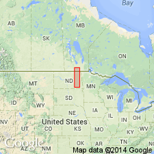
Originally defined in Pembina Mountain, Manitoba, as Pembina beds [Kirk, S. R., 1929, Cretaceous stratigraphy of the Manitoba escarpment: Canada Geological Survey Summary Report, 1929, part B, p. 112B-135B; later called Pembina Member of Vermilion Formation in Manitoba]. Pembina strata continuous south on same escarpment in Manitoba into ND. In ND consists of lower black carbonaceous shale alternating with numerous thin bentonite beds and upper dark-gray to brownish-black shale with a few thin bentonite layers. Reference sections measured: 1.) roadcuts along ND Hwy 46 near Little Yellowstone Park, SW1/4 SW1/4 sec 31, T137N, R57W, and SW1/4 SW1/4 sec 36 and SE1/4 SE1/4 sec 35, T137N, R58W, Barnes Co, ND, 44.6 ft thick (no bentonite-rich part); 2.) NE1/4 sec 25, T161N, R57W, and at spillway cut for Tongue River retention dam T-3-5, SE1/4 NE1/4 sec 25 and along ND Hwy 5, NW1/4 NE1/4 sec 24, T161N, R57W, Cavalier Co, ND, lower part 8 ft thick, upper part 67 ft thick; 3.) roadcut west of Pembina River, SW1/4 sec 30, T163N, R57W, Cavalier Co, ND, 12.6+ ft thick. Overlies Niobrara Formation; underlies Gregory Member of Pierre. Correlated with Claggett Shale, Sharon Springs and overlying Mitten Black Shale Members of Pierre. Index fossils and ammonite zonation shown. Late Cretaceous (Campanian) age.
Source: GNU records (USGS DDS-6; Denver GNULEX).
For more information, please contact Nancy Stamm, Geologic Names Committee Secretary.
Asterisk (*) indicates published by U.S. Geological Survey authors.
"No current usage" (†) implies that a name has been abandoned or has fallen into disuse. Former usage and, if known, replacement name given in parentheses ( ).
Slash (/) indicates name conflicts with nomenclatural guidelines (CSN, 1933; ACSN, 1961, 1970; NACSN, 1983, 2005, 2021). May be explained within brackets ([ ]).