

- Usage in publication:
-
- Park City formation*
- Modifications:
-
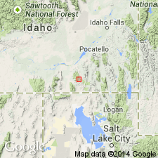
- Named
- Dominant lithology:
-
- Limestone
- Sandstone
- Shale
- AAPG geologic province:
-
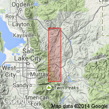
- Uinta uplift
Summary:
Named after the Park City district, Summit Co., UT in the Uinta uplift. Type section designated and measured in Big Cottonwood Canyon. Is made up of gray, gray-white limestone, sandy limestone, buff, gray, calcareous sandstone, white, gray, yellow-gray quartzite and quartzitic sandstone, and red, brown, and olive shale 466 ft thick at type where it overlies Weber quartzite. Is approximately 700 ft at one locality. Underlies Woodside shale (new). Upper Carboniferous faunas collected.
Source: GNU records (USGS DDS-6; Denver GNULEX).
- Usage in publication:
-
- Park City formation*
- Modifications:
-
- Areal extent
- AAPG geologic province:
-
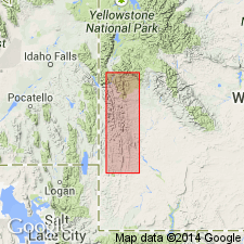
- Green River basin
Summary:
Mapping done in 1906. Follows nomenclature used by Veatch. Name applied to a 1,400 ft thick sequence of red or brown weathering sandstone, shaly sandstone, and laminated sandstone conformably above the Weber quartzite. Mapped (geologic map) with the overlying Triassic Woodside shale (400 ft thick) and Thaynes limestone (2,000 ft thick) in a strip from T23N, R116-117W on south to T40N, R115W on north in Lincoln Co, WY in the Greater Green River basin. Recent work (1912) by Richards and Mansfield in ID has shown that the lower member of the Park City [thickness not stated] is included in their Wells formation and the overlying part [thickness not stated] is included in their Phosphoria formation. Measured section from along north bank of Fontenelle Creek from east base of Absaroka Ridge across first ridge (T27N, R117W) described. Fossils listed. Of Pennsylvanian and Permian? age.
Source: GNU records (USGS DDS-6; Denver GNULEX).
- Usage in publication:
-
- Park City formation*
- Modifications:
-
- Revised
- Areal extent
- AAPG geologic province:
-
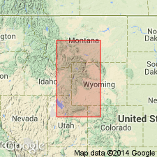
- Uinta basin
Summary:
Name applied to carbonate rock and subordinate sandstone. Much of limestone is bioclastic; brachiopod and bryozoan coquinas are common. Dolomite is also common. Tongues of these lithologies extend into eastern ID (Snake River basin, Great Basin province), western WY (Greater Green River, Bighorn, and Wind River basins, Yellowstone province), and MT (Montana folded belt province) from northern UT (Uinta uplift). Divided into a lower member (Grandeur member), a middle member (Franson member) that are separated by Meade Peak phosphatic shale member of Phosphoria formation, and an upper member (Ervay member) that overlies Tosi chert member of Phosphoria. Formation overlies Tensleep Sandstone and underlies Dinwoody Formation. Fossils occur in all three members. Is a marine unit assigned to Permian.
Permian rocks separable over large area
of western WY, eastern ID, northern UT, northwest CO, and
southwest MT, into three facies. Name Park City applied to
the carbonate facies, name Phosphoria applied to the chert-
mudstone-phosphorite facies, and a new name--Shedhorn sand-
stone--applied to the sandstone facies.
Source: GNU records (USGS DDS-6; Denver GNULEX).
- Usage in publication:
-
- Park City Formation*
- Modifications:
-
- Revised
- AAPG geologic province:
-
- Uinta basin
- Green River basin
Summary:
Triassic Moenkopi Formation-Permian Park City Formation contact modified on the south flank of the Uinta Mountains from Ashley Creek, Uintah Co, UT in the Uinta basin east to Red Rock Canyon, Moffat Co, CO in the Greater Green River basin. A 25 to 67 ft thick unit called tawny beds, formerly mapped as part of the Moenkopi, are removed from the Moenkopi and reassigned to the upper unit of the Franson Member of the Park City. The tawny beds are gray silty limestone and dolomite, and can be traced from Ashley Creek to Red Rock Canyon. A very fine grained, hard, ledge-forming limestone or dolomite marker bed 4 ft thick is distinguishable 10 to 30 ft below top of the tawny beds. The marker contains phosphatic bioclastic debris, phosphate pellets, glauconite, sand, silt, and chert beds. A limestone 0.5 to 3.5 ft thick and 5 to 10 ft below the marker yielded Permian fossils (bryozoans, brachiopods, ammonoids, gastropods, etc, listed). Overlying Moenkopi distinguished by interbedded red-brown and yellow-gray calcareous siltstone that are ripple marked and have gypsum veinlets. Underlying parts of Park City are the lower unit of the Franson.
Source: GNU records (USGS DDS-6; Denver GNULEX).
- Usage in publication:
-
- Park City Formation
- Modifications:
-
- Revised
- AAPG geologic province:
-
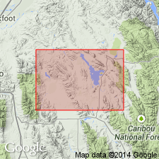
- Great Basin province
- Snake River basin
Summary:
Grandeur Tongue of Permian Park City Formation gradationally overlies Heydlauff Sandstone (a new name) in Sublett Mountains [also called Range], in Great Basin province and Snake River basin, ID.
Source: GNU records (USGS DDS-6; Denver GNULEX).
- Usage in publication:
-
- Park City Formation*
- Modifications:
-
- Revised
- AAPG geologic province:
-
- Great Basin province
Summary:
Revised in that Grandeur Tongue of Park City Formation overlies the newly named Trappers Creek Formation in southeastern part of Cassia Mountains, Cassia Co, ID in the Great Basin province. Grandeur is of early late Leonardian, Early Permian age. No other part of Park City discussed.
Source: GNU records (USGS DDS-6; Denver GNULEX).
- Usage in publication:
-
- Park City Formation*
- Modifications:
-
- Age modified
- Biostratigraphic dating
- AAPG geologic province:
-
- Snake River basin
- Wasatch uplift
Summary:
Grandeur Member is uppermost member of Park City in Caribou Co (Wasatch uplift) and Bingham Co (Snake River basin), southeastern ID. Underlies Meade Peak Phosphatic Shale Member of Phosphoria Formation. Age refined to Roadian (Leonardian) on basis of conodont biostratigraphy. NEOSTREPTOGNATHODUS SULCOPLICATUS Zone (Roadian) identified in Grandeur and lowermost part of Meade Peak. Roadian Stage, Leonardian Series of Early Permian age.
Source: GNU records (USGS DDS-6; Denver GNULEX).
- Usage in publication:
-
- Park City Formation*
- Modifications:
-
- Revised
- AAPG geologic province:
-
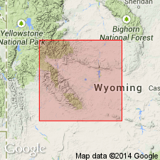
- Wind River basin
Summary:
Designation Ervay Limestone Member of Park City Formation accepted in Wind River Canyon, Fremont Co., WY in Wind River basin. Assigned to Lower Permian.
Source: GNU records (USGS DDS-6; Denver GNULEX).
For more information, please contact Nancy Stamm, Geologic Names Committee Secretary.
Asterisk (*) indicates published by U.S. Geological Survey authors.
"No current usage" (†) implies that a name has been abandoned or has fallen into disuse. Former usage and, if known, replacement name given in parentheses ( ).
Slash (/) indicates name conflicts with nomenclatural guidelines (CSN, 1933; ACSN, 1961, 1970; NACSN, 1983, 2005, 2021). May be explained within brackets ([ ]).