

- Usage in publication:
-
- Paluxy formation
- Modifications:
-
- Revised
- AAPG geologic province:
-
- South Oklahoma folded belt
Summary:
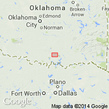
Baum Limestone Member named. Name applied to the limestone facies of the Lower Cretaceous Paluxy Formation in the southern Arbuckle Mountains in southwest Johnson Co, eastern Carter Co, and northwest Marshall Co, OK in the S. Oklahoma folded belt province. Geologic map. A second facies of Paluxy of sand and loosely consolidated sandstone mapped to southwest of body of Baum in southern Johnson and northern Marshall Cos, OK.
Source: GNU records (USGS DDS-6; Denver GNULEX).

- Usage in publication:
-
- Paluxy Formation
- Modifications:
-
- Mapped 1:250k
- Dominant lithology:
-
- Sandstone
- Mudstone
- Limestone
- AAPG geologic province:
-
- Fort Worth syncline
- Strawn basin
Summary:
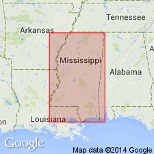
Paluxy Formation. Sandstone, mudstone, and limestone. Sandstone, fine- to very fine-grained, friable to calcite cemented, cross-beds common, in part massive, locally burrowed, light gray to greenish gray; weathers yellowish brown to dusky brown. Mudstone, sandy, massive, locally burrowed, greenish gray, olive green, and medium gray; weathers yellowish brown and red brown. Limestone locally in upper 40 to 50 feet, sandy, fossiliferous, beds 0.5 to 2 feet thick, yellowish gray; weathers mottled dark gray and yellowish brown. Thickness 95 to 105 feet. Lies above Glen Rose Formation and below Walnut Clay. Age is Early Cretaceous.
[Mapped in Bosque, Erath, Hood, Johnson, Parker, Somervell, Tarrant, and Wise Cos., eastern TX.]
Source: Publication.

- Usage in publication:
-
- Paluxy Sand
- Modifications:
-
- Mapped 1:250k
- Dominant lithology:
-
- Sand
- Clay
- AAPG geologic province:
-
- Fort Worth syncline
Summary:
Pamphlet [p. 6]. Paluxy Sand. Sand and clay; sand, light-brownish-yellow to light-gray, very fine-grained to fine-grained, in part argillaceous and silty, thin-bedded to massive, cross-bedded; clay, light-gray to light-red, thin-bedded to massive. Thickness approximately 225 feet. [Correlative with upper part of Antlers Sand.] Lies above Glen Rose Limestone and below Walnut Clay or, where absent, Goodland Limestone. Age is Early Cretaceous.
[Mapped southwest of Decatur, in Jack, Parker, and Wise Cos., central northern TX; in southwestern corner of map sheet.]
Source: Publication.
- Usage in publication:
-
- Paluxy Formation
- Modifications:
-
- Overview
- AAPG geologic province:
-
- Mid-Gulf Coast basin
Summary:
In the study area, the Paluxy is between 1100 and 1450 ft thick. The top of the formation is found at an average subsea elevation of -9400 ft. Section consists of alternating layers of sands, siltstones, and shales. The sands are quite abundant, with lenses 30 to 50 ft thick. Overlies Mooringsport Formation and underlies undifferentiated Washita-Fredericksburg Formations. No production in West Raymond Field. Age is Early Cretaceous (Comanchean).
Source: GNU records (USGS DDS-6; Reston GNULEX).
For more information, please contact Nancy Stamm, Geologic Names Committee Secretary.
Asterisk (*) indicates published by U.S. Geological Survey authors.
"No current usage" (†) implies that a name has been abandoned or has fallen into disuse. Former usage and, if known, replacement name given in parentheses ( ).
Slash (/) indicates name conflicts with nomenclatural guidelines (CSN, 1933; ACSN, 1961, 1970; NACSN, 1983, 2005, 2021). May be explained within brackets ([ ]).