

- Usage in publication:
-
- Negli Creek limestone
- Modifications:
-
- Named
- Dominant lithology:
-
- Limestone
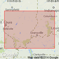
- AAPG geologic province:
-
- Illinois basin
Summary:
Negli Creek limestone is named as uppermost formation of upper Chester of IN. Consists of limestone, usually quite massive, but on weathered faces bedding is well brought out, the beds being from a few in. to a few ft thick. Ranges in color from rusty yellow to white or dove color. Very fossiliferous. Thickness 2 to 20 ft. Lies at or near base of Mansfield sandstone and 15 to 53 above Mount Pleasant sandstone. Named for excellent exposures along Negli Creek, a tributary of Little Deer Creek, 4 or 5 mi east of Tell City, Perry Co. IN. At Buffalo Wallow, KY, 1.5 mi west of Cloverport, Breckinridge Co., it is separated from Mansfield sandstone by 5 ft of upper Chester shale and from underlying Mount Pleasant sandstone by 53 ft of shale.
Source: GNU records (USGS DDS-6; Reston GNULEX).
- Usage in publication:
-
- Negli Creek Member
- Modifications:
-
- Revised
- Areal extent
- AAPG geologic province:
-
- Illinois basin
Summary:
Negli Creek Limestone reduced in rank to Negli Creek Limestone Member of Kinkaid Limestone for usage in IL.
Source: GNU records (USGS DDS-6; Reston GNULEX).

- Usage in publication:
-
- Negli Creek Limestone Member
- Modifications:
-
- Overview
- AAPG geologic province:
-
- Illinois basin
Summary:
Authors here revise Grove Church Shale (of Swann, 1963) as Grove Church Member of Kinkaid Limestone as it does not meet the test of mappability required by the 1983 Code. Interbedded shale and limestone of the Grove Church are lithologically similar to the rest of the Kinkaid. Ascending Negli Creek Limestone, Cave Hill, and Goreville Limestone Members also traceable in outcrop and subsurface in southern IL. The Negli Creek, composed almost entirely of limestone, ranges from 25 to 38 ft thick. Lower part is generally very fine to fine-grained, dark gray to brownish gray limestone. Upper part is gray fine- to coarse-grained, bioclastic limestone with abundant pelmatozoan fragments, fenestrate bryozoans, and brachiopods. Overlies Degonia Formation. Age is Chesterian.
Source: GNU records (USGS DDS-6; Reston GNULEX).
For more information, please contact Nancy Stamm, Geologic Names Committee Secretary.
Asterisk (*) indicates published by U.S. Geological Survey authors.
"No current usage" (†) implies that a name has been abandoned or has fallen into disuse. Former usage and, if known, replacement name given in parentheses ( ).
Slash (/) indicates name conflicts with nomenclatural guidelines (CSN, 1933; ACSN, 1961, 1970; NACSN, 1983, 2005, 2021). May be explained within brackets ([ ]).