The National Geologic Map Database is migrating to a new infrastructure. We apologize for any service disruptions during this process.
|
|---|


- Usage in publication:
-
- Neahga formation
- Modifications:
-
- Named
- Dominant lithology:
-
- Shale
- AAPG geologic province:
-
- Appalachian basin
Summary:
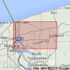
The term Neahga (meaning Niagara River), which can be used as a local name implying no correlation, is proposed to designate the lower Clinton green shale at Niagara Gorge. Unit is 6 ft thick and thins to the east. It is nearly or completely missing at Lockport, where about 3 in. of green shale occur between underlying Thorold sandstone and overlying Reynales limestone. Originally correlated by Hall with green shale below PENTAMERUS LIMESTONE at Rochester (Maplewood shale) to which it corresponds in stratigraphic position. Fossils seem more closely related to overlying formations. Between the Neahga and underlying Thorold sandstone is a bed of calcitic sandy rock, with possibly a small unconformity at its base. The bed of green shale may be of Furnaceville age, or may correspond at least approximately to Maplewood shale, but laid down in separate basin or embayment or under different environment.
Source: GNU records (USGS DDS-6; Reston GNULEX).
- Usage in publication:
-
- Neahga Shale
- Modifications:
-
- Areal extent
- AAPG geologic province:
-
- Appalachian basin
Summary:
The name Maplewood has been abandoned for the basal shale of the Clinton Group in the study area and is replaced by the name Neahga, which has been extended throughout the outcrop belt.
Source: GNU records (USGS DDS-6; Reston GNULEX).
- Usage in publication:
-
- Neahga Shale
- Modifications:
-
- Revised
- Areal extent
- Biostratigraphic dating
- AAPG geologic province:
-
- Appalachian basin
Summary:
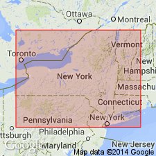
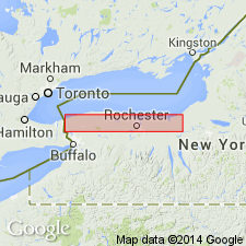
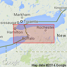
As currently defined the basal formation of the Clinton Group is the Neahga Shale in western NY and adjacent Ontario, and the Maplewood Shale in Monroe Co., NY. The base of both units is marked by a distinctive phosphatic bed, herein termed the Densmore Creek Bed. The top is marked by a second phosphatic bed, the Budd Road Bed. The Neahga is platy, fissile, dark gray to olive greenish gray clay shale with minor amounts of quartz silt. Thickness varies from a feather-edge near Lockport up to about 2 m at Niagara Gorge. Distribution is limited to the area between St. Catharines, Ontario, where it is truncated by a late Llandoverian unconformity, and Lockport, NY. Llandoverian B-2 to C-1 age assignment of the Neahga is based on conodonts and brachiopod HYATTIDINA CONGESTA. Overlies the Cambria Shale or Kodak Sandstone, here assigned to the top of the Medina Group.
Source: GNU records (USGS DDS-6; Reston GNULEX).
- Usage in publication:
-
- Neahga Shale*
- Modifications:
-
- Overview
- AAPG geologic province:
-
- Appalachian basin
Summary:
The Neahga Shale of the Clinton Group consists of green to gray, slightly silty, slightly calcareous, soft, and highly fissile shale. Fossils are scarce and consists mainly of linguloid brachiopods. Unit is lowest formation in Clinton Group. The basal bed of the Neahga is the Densmore Creek Phosphate Bed. The Neahga is 2 to 6 ft thick. Unit is well exposed along railroad track north of junction with Niagara Road immediately west of Lockport, NY; roadcut along Budd Road 1.3 mi west of Hickory Corners, NY; and in cliff in east wall of Niagara River gorge about 0.3 miles north of Robert Moses powerplant and 1.4 mi south of Artpark, in Lewiston, NY. Unconformably overlies the various units of the Medina Group (Kodak Sandstone, highest formation) and unconformably underlies the Reynales Limestone. The Neahga is of Early Silurian (Llandoverian) age. [Report uses Early and Late Silurian time scale of Harland and others (1982).]
Source: GNU records (USGS DDS-6; Reston GNULEX).
For more information, please contact Nancy Stamm, Geologic Names Committee Secretary.
Asterisk (*) indicates published by U.S. Geological Survey authors.
"No current usage" (†) implies that a name has been abandoned or has fallen into disuse. Former usage and, if known, replacement name given in parentheses ( ).
Slash (/) indicates name conflicts with nomenclatural guidelines (CSN, 1933; ACSN, 1961, 1970; NACSN, 1983, 2005, 2021). May be explained within brackets ([ ]).