The National Geologic Map Database is migrating to a new infrastructure. We apologize for any service disruptions during this process.
|
|---|


- Usage in publication:
-
- Naturita formation
- Modifications:
-
- Original reference
- Dominant lithology:
-
- Sandstone
- Mudstone
- Conglomerate
- Siltstone
- Coal
- AAPG geologic province:
-
- Piceance basin
- Paradox basin
Summary:
Pg. 17, 21, figs. 2, 3; 1960, AAPG Bull., v. 44, no. 2, p. 156-194. Naturita formation of Dakota group. Carbonaceous unit consisting of conglomeratic sandstone, carbonaceous mudstone, carbonaceous shale, coal, littoral marine sandstone, and thin tongues of Mancos shale. Throughout much of the area, basal unit is a white to light-gray (on fresh surfaces), buff (on weathered surfaces) thin (5 to 15 feet) conglomeratic sandstone which disconformably overlies Cedar Mountain formation. In much of the area, a similar sandstone, about 20 feet thick, occurs higher in formation above as much as 45 feet of carbonaceous deposits. Upper part of formation of gray to black silty carbonaceous mudstone with lenses of conglomerate, sandstone, shale, and coal, about 100 feet thick. All of the formation in eastern part of the area is of Early Cretaceous age, but upper part in western part of the area is of Late Cretaceous age. Underlies Mancos shale.
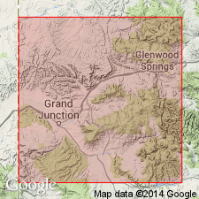
Named from exposures near Naturita, [Montrose Co.], southwestern CO. In Grand Junction area, Garfield, Mesa, and Delta Cos.
Source: GNU records (USGS DDS-6; Denver GNULEX).
- Usage in publication:
-
- Naturita Formation
- Modifications:
-
- Overview
- Dominant lithology:
-
- Sandstone
- Shale
- AAPG geologic province:
-
- Paradox basin
Summary:
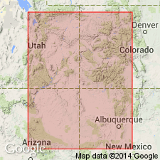
Type section designated and measured on north side of San Miguel River, about 2,000 ft northwest of Nuclear Power Plant, SE1/4 NE1/4 sec 13, T46N, R15W, Montrose Co, CO, Paradox basin. At type, Naturita is 119.8 [does not include tongues of Mancos] ft thick; it overlies Cedar Mountain Formation of Dakota Group and underlies Mancos Shale. Isopach map. Ranges from 50 to 175 ft thick. Present in northwest NM, northeast AZ, western CO, and eastern UT. Thickest section occurs in southwestern CO near the Four Corners area. Name applied to the upper or carbonaceous part of Dakota Group. At type, consists of: gray to tan, fine-, medium-, to coarse-grained sandstone, some beds of which may be silty, moderately well-sorted, ripple marked; dark-gray to black carbonaceous shale. Four interbedded calcareous dark-gray shales that total 2.4 ft thick identified as tongues of Mancos. [Thicknesses on isopach map may include tongues of Mancos.] Cross section. Of Early and Late Cretaceous age.
Source: GNU records (USGS DDS-6; Denver GNULEX).
For more information, please contact Nancy Stamm, Geologic Names Committee Secretary.
Asterisk (*) indicates published by U.S. Geological Survey authors.
"No current usage" (†) implies that a name has been abandoned or has fallen into disuse. Former usage and, if known, replacement name given in parentheses ( ).
Slash (/) indicates name conflicts with nomenclatural guidelines (CSN, 1933; ACSN, 1961, 1970; NACSN, 1983, 2005, 2021). May be explained within brackets ([ ]).