The National Geologic Map Database is migrating to a new infrastructure. We apologize for any service disruptions during this process.
|
|---|


- Usage in publication:
-
- Nassawadox Formation*
- Modifications:
-
- Named
- Dominant lithology:
-
- Sand
- Gravel
- AAPG geologic province:
-
- Atlantic Coast basin
Summary:
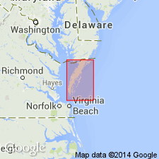
Surficial sand and gravel deposits that underlie the Franktown plain and central upland in the area south of the Ames Ridge shoreline in VA are here named the Nassawadox Formation. It contains the lower subsurface Stumptown Member, which unconformably overlies the Yorktown Formation; the Butlers Bluff Member, which forms the upper part of the Nassawadox in the southern upland area; and the Occohannock Member, on the west side of the bluff formed by the Butlers Bluff Member. Thickness at type section is 200 ft (60 m). Age is Pleistocene.
Source: GNU records (USGS DDS-6; Reston GNULEX).

- Usage in publication:
-
- Nassawadox Formation
- Modifications:
-
- Overview
- AAPG geologic province:
-
- Atlantic Coast basin
Summary:
Nomenclature on State map follows Mixon (1985). Nassawadox Formation is surficial sandy and gravelly deposits of narrow, flat upland and adjacent bay-side terrace in Northampton and southernmost Accomac Cos. Butlers Bluff (60 ft) and Occohannock (20 ft) Members are mapped. Stumptown Member (140 ft), is present only in subsurface. Age is late Pleistocene.
Source: GNU records (USGS DDS-6; Reston GNULEX).
For more information, please contact Nancy Stamm, Geologic Names Committee Secretary.
Asterisk (*) indicates published by U.S. Geological Survey authors.
"No current usage" (†) implies that a name has been abandoned or has fallen into disuse. Former usage and, if known, replacement name given in parentheses ( ).
Slash (/) indicates name conflicts with nomenclatural guidelines (CSN, 1933; ACSN, 1961, 1970; NACSN, 1983, 2005, 2021). May be explained within brackets ([ ]).