

- Usage in publication:
-
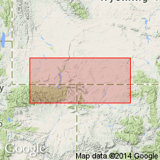
- Moxa erosion surface
- Modifications:
-
- First used
- AAPG geologic province:
-
- Green River basin
Summary:
First used for erosion surface across the Church Buttes anticline, Uinta Co, WY in southwestern part of Greater Green River basin. Derivation of name not given. Probably named for Moxa, Lincoln Co, WY. Is defined by a thin sequence of sandstones and conglomerates of Ericson Formation that unconformably overlies the marine Hilliard Shale. Rock Springs Formation is interpreted to have been stripped by erosion from the crest of the anticline prior to deposition of Ericson. Age is Late Cretaceous.
Source: GNU records (USGS DDS-6; Denver GNULEX).
For more information, please contact Nancy Stamm, Geologic Names Committee Secretary.
Asterisk (*) indicates published by U.S. Geological Survey authors.
"No current usage" (†) implies that a name has been abandoned or has fallen into disuse. Former usage and, if known, replacement name given in parentheses ( ).
Slash (/) indicates name conflicts with nomenclatural guidelines (CSN, 1933; ACSN, 1961, 1970; NACSN, 1983, 2005, 2021). May be explained within brackets ([ ]).