

- Usage in publication:
-
- Moulton Member
- Modifications:
-
- First used
- Dominant lithology:
-
- Siltstone
- Shale
- Mudstone
- Sandstone
- AAPG geologic province:
-
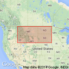
- Sweetgrass arch
Summary:
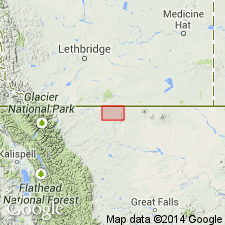
First published use as one of four members of the Kootenai Formation in Glacier Co, MT on the Sweetgrass arch. Intent to name not stated. Type log is the Montana Power Farbo No. 4, in SWNWSE sec 3, T37N, R4W in Glacier Co. Occurs in the North Cut Bank field area on the northwest plunge of North Arch in north-central MT. Is a lake and swamp to fluviatile deposit that is up to 100 feet thick. Consists of medium to dark-brownish-gray siltstone laminated with black carbonaceous shale, greenish-gray sandy shale, varicolored mudstone, with thin beds of fine to very fine grained light-gray sandstone; the sandstone locally contains clay lumps and siltstone pebbles. Basal 4-10 ft, called the "brown lime" submember of the Moulton member, is a brown marl and/ or gray calcareous siltstone laminated with white, very fine grained limey sandstone. Shales have mudcracks filled with light-gray, very fine grained sandstone. Sandstone is up to 50 ft thick and split laterally by gray to black carbonaceous shales; sandstones composed of fine- to coarse-grained subangular to rounded quartz, black to gray chert, with some red and amber chalcedony, and green hornblende?. Medium- to coarse-grained sandstone interbeds are salt and pepper with 5-50 percent subangular dark chert. Overlies Lander member (first used) of Kootenai Formation; underlies unnamed varicolored sandy shale member of Kootenai. Geologic map. Cross sections. Of Early Cretaceous age.
Source: GNU records (USGS DDS-6; Denver GNULEX).
- Usage in publication:
-
- Moulton Member*
- Modifications:
-
- Revised
- AAPG geologic province:
-
- Sweetgrass arch
Summary:
Moulton Member, uppermost member of Kootenai Formation. Moulton sand (economic term) adopted as Moulton Member of Kootenai Formation, as defined by Oakes (1966). Consists of siltstone, carbonaceous shale, and mudstone with thin sandstones. The basal part contains a marl and (or) calcareous siltstone which forms an excellent marker bed containing freshwater ostracodes, pelecypods, and gastropods. Overlies Sunburst Sandstone Member (revised) of Kootenai (=Oakes' Lander Member).
Type section (subsurface): depth-interval 2,388 to 2,485 ft (728 m to 757 m), Montana Power Farbo No. 4 well, in SW/4 NW/4 SE/4 sec. 3, T. 37 N., R. 4 W., Glacier Co., MT (Oakes, 1966, p. 197-198).
Source: Changes in stratigraphic nomenclature, 1975 (USGS Bull. 1422-A, p. A28-A29, A66-A67).
For more information, please contact Nancy Stamm, Geologic Names Committee Secretary.
Asterisk (*) indicates published by U.S. Geological Survey authors.
"No current usage" (†) implies that a name has been abandoned or has fallen into disuse. Former usage and, if known, replacement name given in parentheses ( ).
Slash (/) indicates name conflicts with nomenclatural guidelines (CSN, 1933; ACSN, 1961, 1970; NACSN, 1983, 2005, 2021). May be explained within brackets ([ ]).