

- Usage in publication:
-
- Moroni formation
- Modifications:
-
- Original reference
- Dominant lithology:
-
- Tuff
- Breccia
- Conglomerate
- Sandstone
- AAPG geologic province:
-
- Wasatch uplift
Summary:
Pg. 381-382. Moroni Formation. Consists of varied pyroclastic rocks (thought to be largely water-laid); metamorphosed tuff, breccia, volcanic conglomerate, green sandstones, and conglomerates. Thickness varies; maximum about 1,500 feet. Overlaps all older exposed formations: in places the relief on the unconformity amounts to 1,000 feet in less than 1 mile. Age is middle or late Tertiary.
Named for the town of Moroni [Moroni 7.5-min quadrangle, Sanpete Co., north-central UT], with type locality at The Cliff, nearby.
[In 1951 (GSA Bull., v. 62, no. 6, p. 619-646) Schoff appears to discard this name. He refers to these rocks as "pyroclastic rocks."]
Source: US geologic names lexicon (USGS Bull. 1200, p. 2594).
- Usage in publication:
-
- Moroni Formation
- Modifications:
-
- Overview
- AAPG geologic province:
-
- Wasatch uplift
Summary:
Moroni Formation. Author summarizes previous mapping studies by Ohio State University graduate students (e.g., Cooper, 1956, and Schoff, 1937). Consists of stratified clastics largely of volcanic origin. Lower part is stream deposits intermixed with normal fluvial sediments; upper part largely tuffs and welded tuffs or ignimbrites. Thickness at type about 2,000 feet. Lies unconformably on Crazy Hill Formation of late Eocene age and is cut by faults apparently associated with Basin-and-Range faulting. Certain members bear similarities to Miocene tuffs in surrounding areas, and this age has been tentatively assigned.
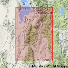
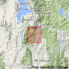
Type locality: highest point in Cedar Hills, about 7 mi north-northeast of Moroni, known locally as The Cliff, Sanpete Co., north-central UT.
Source: Publication.
- Usage in publication:
-
- Moroni Formation*
- Modifications:
-
- Age modified
- AAPG geologic province:
-
- Wasatch uplift
Summary:
Dated as 32-33 m.y. old on west wall of Thistle Creek, Utah Co on the Wasatch uplift near escarpment formed on the Charleston-Nebo allochthon. Age changed to Oligocene?.
Source: GNU records (USGS DDS-6; Denver GNULEX).
- Usage in publication:
-
- Moroni Formation*
- Modifications:
-
- Age modified
- Areal extent
- Geochronologic dating
- AAPG geologic province:
-
- Wasatch uplift
Summary:
Is a formation used east of a north-trending lowland formed by the Juab-Sevier River valleys, Sanpete Co, UT, Wasatch uplift. Divisible into a lower unit chiefly of water-laid sediments and an upper unit chiefly of ash-flow and welded tuffs. Both units contain abundant clasts of red-gray andesite, purple quartzite (from Mutual Quartzite), tan quartzite (from Tintic Quartzite), and dark-blue Paleozoic limestone. Exact thickness not known. Lower unit is about 1,800 ft thick. Upper unit is about 1,560 ft thick. May unconformably overlie Crazy Hollow Formation or older rocks. Two units thought to correspond to lower and upper units of Goldens Ranch Formation, its correlative used west of Juab-Sevier River valleys (location of arbitrary nomenclature change). Is folded and faulted indicating structural deformation after emplacement. Has K-Ar ages of 33.6 +/-1.2 to 35.4 +/-1.3 Ma (biotite), 30.6 +/-1.1 Ma (sanidine), 37.8 +/-2.2 Ma (hornblende), 32.8 +/-3.3 to 37.7 +/-2.4 Ma (plagioclase). Age changed from Oligocene? to late Eocene to middle Oligocene. Correlation chart. Derived from East Tintic Mountains.
Source: GNU records (USGS DDS-6; Denver GNULEX).
- Usage in publication:
-
- Moroni Formation
- Modifications:
-
- Age modified
- Biostratigraphic dating
- AAPG geologic province:
-
- South Western Overthrust
Summary:
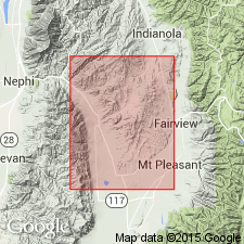
Moroni Formation. New fossil camel species BLICKOMYLUS MORONI sp. nov. of late early Miocene (Hemingfordian NALMA) age is described from the upper part of the Moroni Formation. Collected from sec. 13, T. 11 S., R. 4 E., [Indianola 7.5-min quadrangle], Utah Co., north-central UT.
Moroni Formation considered to have a distinctive bipartite stratigraphy, consists of: (1) lower part, upper Eocene to lower Oligocene boulder conglomerate of interbedded volcanic mudflow and fluvial deposits, 600+m thick; and (2) upper part, upper lower to lower middle Miocene alluvial fan-braided stream deposits of massive beds of coarse-grained, tuffaceous sandstone intercalated with occasional thin- to medium-bedded boulder-cobble conglomerate, cross-stratified sandstone, and rare limestone, 200m thick.
Source: Publication.
For more information, please contact Nancy Stamm, Geologic Names Committee Secretary.
Asterisk (*) indicates published by U.S. Geological Survey authors.
"No current usage" (†) implies that a name has been abandoned or has fallen into disuse. Former usage and, if known, replacement name given in parentheses ( ).
Slash (/) indicates name conflicts with nomenclatural guidelines (CSN, 1933; ACSN, 1961, 1970; NACSN, 1983, 2005, 2021). May be explained within brackets ([ ]).