The National Geologic Map Database is migrating to a new infrastructure. We apologize for any service disruptions during this process.
|
|---|


- Usage in publication:
-
- Morita Ranch Formation
- Modifications:
-
- Areal extent
- AAPG geologic province:
-
- Permian basin
Summary:
Pg. 27, pI. 2, road logs. Morita Ranch Formation. Rix, 1953 [Univ. Texas-Austin unpub. PhD dissert.] described two successions of volcanic rock in Chinati Peak quadrangle, with outcrops separated by Paleozoic rock or gravel in Cibolo Creek valley. He divided volcanic rock east of Cibolo Creek into four mappable units (T1 through T4) and correlated the units with formations of Buck Hill Group. He mapped the thick succession of flows in Chinati Mountains as the Chinati Mountain Group (units T5 through T8). He considered Chinati Mountain Group to be younger than flows correlated with Buck Hill Group. Dietrich (1965, in press) included Rix's units Tl through T4 and other rocks that crop out east and southeast of Shafter in Morita Ranch Formation. Correlation has not been established between flow rock in Chinati Mountain Group (Rix's units T5 through T8) and Shely Group to northwest or Morita Ranch Formation to southeast. Future work may establish better correlation between Buck Hill Group and Morita Ranch Formation. Age is Tertiary.
Source: US geologic names lexicon (USGS Bull. 1350, p. 504).
- Usage in publication:
-
- Morita Ranch Formation
- Modifications:
-
- Principal reference
- Dominant lithology:
-
- Basalt
- Rhyolite
- AAPG geologic province:
-
- Permian basin
Summary:
Morita Ranch Formation. Formal proposal of name. Name is proposed for the succession of interbedded flow and sedimentary rocks that crops out between pre-Cenozoic strata and Perdiz Conglomerate at southeastern end of Chinati Mountains, southwestern Texas. Following members mapped in Presidio area (ascending): basalt porphyry, rhyolite, ash-flow tuff, and basalt. The basalt porphyry overlies intrusive rock of Morita pluton and all pre-Cenozoic formations that crop out in map area except Santa Elena Limestone. The basalt porphyry includes many flows 20 to 40 feet thick. Maximum exposed thickness in Presidio area is between 150 and 200 feet. The rhyolite crops out along Cienega Creek near northern boundary of map area. Greatest exposed thickness is about 300 feet where Cienega Creek cuts a canyon through largest outcrop. The ash-flow tuff conformably overlies basalt porphyry in southeastern Chinati Peak quadrangle. Near northern boundary of Presidio area the tuff oversteps pre-Cenozoic rock. At all outcrops in Ocotillo quadrangle the ash-flow tuff overlies Santa Elena Limestone or Sue Peaks Formation. Thickness of ash-flow tuff as much as 75 feet. Highest lava unit is basalt. Maximum exposed thickness in Presidio area is on the order of 250 feet. Type locality designated. No type section presented.
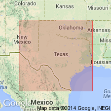
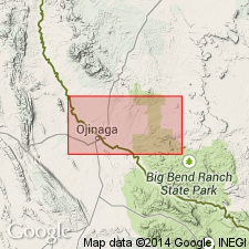
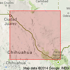
Type locality: northern end of the Three Sisters, a mountain 1.3 mi southeast of Shafter, Presidio Co., southwestern TX. Named from Morita Ranch, 4 mi southeast of Shafter, in Chinati Peak quadrangle, southwestern TX.
Source: US geologic names lexicon (USGS Bull. 1350, p. 504).
- Usage in publication:
-
- Morita Ranch Formation
- Modifications:
-
- Geochronologic dating
- AAPG geologic province:
-
- Permian basin
Summary:
Pg. 19. Morita Ranch Formation. Divided into (ascending) informal members 1 through 4; member 4 correlates with member 6 of Shely Group. Lava flow and ash-flow tuff (rhyolite) samples from Shafter quadrangle, Presidio County, southwestern Texas, yielded K-Ar ages from 37.3 +/-0.7 Ma to 32.6 +/-0.7 Ma (alkali feldspar, biotite). Data from J.C. Cepeda and C.D. Henry, 1983 (Univ. Texas-Austin Bur. Econ. Geol. Rpt. Inv. No. 135, 32 p.), C.D. Henry and J.G. Price, 1984 (Jour. Geophysical Res., v. 89, p. 8765-8786), and C.C. Rix, 1953 (Univ. Texas-Austin, PhD dissert., 188 p.); ages recalculated using decay constants of Steiger and Jager, 1977 (Earth Planet. Sci. Letters, v. 36, p. 359-362).
[Age considered Eocene to Oligocene; Eocene-Oligocene boundary 36.6 (38-34) Ma (from Geologic Names Committee, USGS, 1983 ed. geol. time scale, with additions from N.J. Snelling, 1985, The Geol. Soc. Mem., no. 10).]
Source: Publication.
For more information, please contact Nancy Stamm, Geologic Names Committee Secretary.
Asterisk (*) indicates published by U.S. Geological Survey authors.
"No current usage" (†) implies that a name has been abandoned or has fallen into disuse. Former usage and, if known, replacement name given in parentheses ( ).
Slash (/) indicates name conflicts with nomenclatural guidelines (CSN, 1933; ACSN, 1961, 1970; NACSN, 1983, 2005, 2021). May be explained within brackets ([ ]).