

- Usage in publication:
-
- Moonstone Formation*
- Modifications:
-
- Named
- Dominant lithology:
-
- Claystone
- Shale
- Sandstone
- Limestone
- Conglomerate
- AAPG geologic province:
-
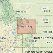
- Wind River basin
Summary:
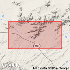
Named for Moonstone a smooth monolith of Precambrian granite against which Moonstone was deposited. Type section measured at SW1/4 sec 4, T30N, R89W southward to the stratigraphically highest bed in Vice Pocket, NE1/4 NE1/4 SE1/4 sec 33, T30N, R89W, Natrona Co, WY in Wind River basin. Is of white to brown claystone, shale, and tuffaceous sandstone, and lesser amounts of limestone, conglomerate, and pumicite. Is 1,356+/-ft thick at its type where it overlies Miocene Split Rock Formation (new) with a slight angular unconformity. No younger rocks present at type. Was deposited around high steep-sided granite knobs. Sandstone beds have angular grains of quartz and feldspar probably derived from adjacent granites. Pliocene age assignment based on diatom assemblages. Camelid cannon bone (of the type found in Miocene and Pliocene camels), rodent teeth, pollen, and fossil wood.
Source: GNU records (USGS DDS-6; Denver GNULEX).
- Usage in publication:
-
- Moonstone Formation*
- Modifications:
-
- Not used
Summary:
Used locally only in Granite Mountains area, Fremont and Natrona Cos., WY in the Wind River basin. Occurs mainly in an area of about 50 sq mi in and adjacent to T30N, R89W. Not used in this report; name Moonstone has limited use as a rock-stratigraphic unit and is referred to in this report as part of the Ogallala Formation [though author does not actually assign Moonstone as a member of Ogallala].
Source: GNU records (USGS DDS-6; Denver GNULEX).
- Usage in publication:
-
- Moonstone Formation*
- Modifications:
-
- Age modified
- AAPG geologic province:
-
- Wind River basin
Summary:
Considered to be late Miocene age rather than Pliocene because of change in date of Miocene-Pliocene boundary. "Age of upper parts of uppermost Miocene units is problematic. These parts have historically been assigned to the Pliocene. Successive reductions in radiometric age of the top of the Miocene in Europe to 7 Ma (Lambert, 1971) and to 5 Ma (Berggren, 1972) place a Pliocene age in question, although the top beds of the formations have not been dated."
Source: GNU records (USGS DDS-6; Denver GNULEX).
For more information, please contact Nancy Stamm, Geologic Names Committee Secretary.
Asterisk (*) indicates published by U.S. Geological Survey authors.
"No current usage" (†) implies that a name has been abandoned or has fallen into disuse. Former usage and, if known, replacement name given in parentheses ( ).
Slash (/) indicates name conflicts with nomenclatural guidelines (CSN, 1933; ACSN, 1961, 1970; NACSN, 1983, 2005, 2021). May be explained within brackets ([ ]).