

- Usage in publication:
-
- Moneta biotite-hornblende gneiss
- Modifications:
-
- Named
- Dominant lithology:
-
- Gneiss
- AAPG geologic province:
-
- Piedmont-Blue Ridge province
Summary:
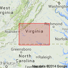
Moneta biotite-hornblende gneiss occurs in area mapped as Lynchburg gneiss (Precambrian) on 1928 map of VA. It is described as mica gneiss and mica schist, in part garnetiferous. The gneiss in Moneta-Bells area differs so much from general character of Lynchburg gneiss that writer has named it Moneta gneiss, from Moneta, Bedford Co., where it is best known. It is prevailing type in Moneta-Bells area. Consists of two distinct lithologic types, biotite gneiss and hornblende gneiss, so intimately associated that they cannot be separately mapped. The two types may represent different beds in original sediments, both be of igneous origin, or one may be igneous and the other sedimentary.
Source: GNU records (USGS DDS-6; Reston GNULEX).

- Usage in publication:
-
- Moneta Gneiss
- Modifications:
-
- Revised
- AAPG geologic province:
-
- Piedmont-Blue Ridge province
Summary:
Moneta Gneiss is here assigned to the Lynchburg Group because of its intertonguing relations with basal conglomeratic Lynchburg rocks and with similar rocks in the base of the Ashe Formation southwest of Lynchburg. Described as moderate-olive-brown to dusky-yellowish-green to black-and-white-banded, medium- to fine-grained biotite-hornblende gneiss, with interlayers of light gray, fine-grained quartz feldspar gneiss, amphibolite, and mica schist. Felsitic crystal tuff breccia, feldspathic conglomerate, and mafic and felsic dikes and sills are present within the unit along the James River west of Lynchburg. Lavas and tuffs in the Moneta were recognized by Wang and Glover (1991) who interpreted the unit as a Late Precambrian volcanic-sedimentary complex.
Source: GNU records (USGS DDS-6; Reston GNULEX).
- Usage in publication:
-
- Moneta Gneiss
- Modifications:
-
- Not used
- AAPG geologic province:
-
- Piedmont-Blue Ridge province
Summary:
Rocks mapped as Moneta Gneiss in the area around 80 degrees west longitude [southwestern VA] by Conley and Henika (1970), Henika (1971), and Conley (1978) are interpreted as Ashe Formation by Rankin and others (1973). In the Bedford-Otter River area of VA, Diggs (1963) mapped Moneta Gneiss as alternating lenses of biotite gneiss which cannot be separately mapped. Lynchburg Formation is mapped as infolds of Moneta, with the contact between Lynchburg and Moneta sharp to gradational. The name Moneta is probably unjustified. No solid evidence is presented that the conglomerate layers of Lynchburg are infolds. A gradational contact between ultramafic-bearing stratified rocks (Lynchburg) and granitic basement (Moneta) is unlikely. Rocks mapped as Reusens migmatite facies of the Moneta Gneiss by Brown (1958, 1970) should not have been associated with Moneta Gneiss.
Source: GNU records (USGS DDS-6; Reston GNULEX).
- Usage in publication:
-
- Moneta Formation
- Modifications:
-
- Revised
- Overview
- AAPG geologic province:
-
- Appalachian basin
Summary:
Unit here referred to as Moneta Formation, mapped by Brown (1958) as Reusens Migmatite. Described as a volcanic-subvolcanic-epiclastic unit. Can be traced as far as 25 mi along strike. The boulder meta-conglomeratic sandstones occur mostly near the contact with the basement where volcanic rocks are absent. The boulders, as large as 1 m in diameter with a matrix of fine- to coarse-grained sand and mud have been interpreted as an alluvial fan deposit of debris flow origin. Both the Moneta and overlying Lynchburg Group appear to have formed in a rifting environment during the Late Proterozoic. The Moneta volcanics, composed of felsites and mafic amphibolites, may be coeval with the Grandfather Mountain volcanics or may be a basal subvolcanic-volcanic suite of the Lynchburg. Isotopic dating is in progress.
Source: GNU records (USGS DDS-6; Reston GNULEX).
For more information, please contact Nancy Stamm, Geologic Names Committee Secretary.
Asterisk (*) indicates published by U.S. Geological Survey authors.
"No current usage" (†) implies that a name has been abandoned or has fallen into disuse. Former usage and, if known, replacement name given in parentheses ( ).
Slash (/) indicates name conflicts with nomenclatural guidelines (CSN, 1933; ACSN, 1961, 1970; NACSN, 1983, 2005, 2021). May be explained within brackets ([ ]).