

- Usage in publication:
-
- Mesnard quartzite*
- Modifications:
-
- Named
- Dominant lithology:
-
- Quartzite
- Conglomerate
- Slate
- Graywacke
- AAPG geologic province:
-
- Lake Superior region
Summary:
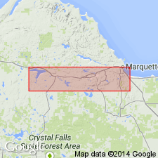
Is Algonkian formation named at base of Lower Marquette series and mapped (pl XIII) in mostly continuous belt adjacent to and south of the Archean; "is given the name Mesnard quartzite because it composes the larger part of the mass of Mount Mesnard south of Marquette";. Mount Mesnard shown on map in secs 34 and 35, T48N, R25W, Marquette Co., MI (Lake Superior region). Is overlain by Kona dolomite (new) of Lower Marquette series. Is about 600 ft thick. Is divisible into four members (ascending): 1) conglomerate, 2) slate and graywacke, 3) quartzite, and 4) slate. Basal conglomerate is a coarse granite conglomerate or sometimes a "recomposed" granite. Slate and graywacke member is very closely folded. Quartzite (the predominant member) is generally a pure vitreous quartzite, massive, but locally ripple-marked. Slate member is 30-100 ft thick; persistent unit between the quartzite and Kona dolomite above.
Source: GNU records (USGS DDS-6; Denver GNULEX).
- Usage in publication:
-
- Mesnard Quartzite*
- Modifications:
-
- Revised
- Age modified
- AAPG geologic province:
-
- Lake Superior region
- Wisconsin arch
Summary:
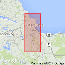
Pg. 34-37. Mesnard Quartzite of Chocolay Group of Animikie series. Present in Marquette and Sands 7.5-min quadrangles, Marquette County, northwestern Michigan (Lake Superior region). Restricted to the thick and massive vitreous quartzite. Quartzite is generally colorless to light-gray, weathers white to shades of pink or light-red; in places interlayered with thin beds of gray slate, quartz-pebble conglomerate, and wacke. Base of Mesnard is now placed where massive white-weathering vitreous quartzite first appears above the quartz wacke or sericite slate of the Enchantment Lake Formation (new) of Chocolay Group. Underlies Kona Dolomite of Chocolay Group; top of Mesnard is at horizon where vitreous quartzite gives way to slate that in turn is overlain by dolomite, or where quartzite passes almost directly into dolomite. Age is considered middle Precambrian (early Animikie). Mesnard is considered to be a direct correlative of the middle Precambrian Sturgeon Quartzite of Iron and Dickinson Counties, Michigan. However, because of the downward extension of the Animikie in northern Michigan by James (1958), the Mesnard is at a lower horizon than the base of the type Animikie in Thunder Bay area, Ontario, Canada. Report includes geologic maps, correlation chart.
Source: Publication; Changes in stratigraphic nomenclature, 1968 (USGS Bull. 1294-A, p. A12).
- Usage in publication:
-
- Mesnard Quartzite*
- Modifications:
-
- Overview
- AAPG geologic province:
-
- Lake Superior region
Summary:
Pg. 2845 (fig. 2, stratigraphic chart compiled from Leith and others, 1935; James, 1958; Gair and Thaden, 1968). Mesnard Quartzite of Chocolay Group of Marquette Range Supergroup (new; replaces †Animikie series of James, 1958, south of Lake Superior, in Michigan and Wisconsin). Present in Marquette Range, northwestern Michigan. Overlies Enchantment Lake Formation and underlies Kona Dolomite, both of Chocolay Group. Age is middle Precambrian.
Source: Publication.
- Usage in publication:
-
- Mesnard Quartzite*
- Modifications:
-
- Overview
- Revised
- Dominant lithology:
-
- Quartzite
- AAPG geologic province:
-
- Lake Superior region
Summary:
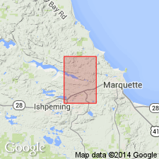
Is middle Precambrian formation mapped in narrow east-west trending belt on north limb of Eagle Mills syncline across southern part of Negaunee quadrangle, Marquette Co, MI (Lake Superior region). Is metasedimentary unit within Chocolay Group (revised) of Marquette Range Supergroup (revised) in Marquette syncline. Overlies Enchantment Lake Formation of Chocolay Group; overlain by Kona Dolomite of Chocolay. Quartzite, generally fine grained, light gray with pinkish zones, cross-bedded, and ripple marked and with beds as thick as several ft; lenticular; maximum thickness 200 ft. Mesnard consisted of seven lithologic units as previously mapped by Seaman east of Teal Lake (in Van Hise and Leith, 1911, p. 19). Revised here in that Seaman's three highest units (red quartzite, purple slate, and cherty quartzite) are placed in Kona Dolomite; Seaman's fourth or middle unit (vitreous quartzite) is assigned to Mesnard Quartzite; and Seaman's three lowest units comprise the Enchantment Lake Formation as mapped herein (pl. 1).
Source: GNU records (USGS DDS-6; Denver GNULEX).
For more information, please contact Nancy Stamm, Geologic Names Committee Secretary.
Asterisk (*) indicates published by U.S. Geological Survey authors.
"No current usage" (†) implies that a name has been abandoned or has fallen into disuse. Former usage and, if known, replacement name given in parentheses ( ).
Slash (/) indicates name conflicts with nomenclatural guidelines (CSN, 1933; ACSN, 1961, 1970; NACSN, 1983, 2005, 2021). May be explained within brackets ([ ]).