

- Usage in publication:
-
- Masonic Park Tuff*
- Modifications:
-
- Named
- Dominant lithology:
-
- Quartz latite
- AAPG geologic province:
-
- San Luis basin
- San Juan Mountains province
Summary:
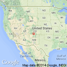
Named for palisade exposures at type area along Rio Grande valley near Masonic Park, 5 km northwest of South Fork, Rio Grande Co, CO in San Luis basin. Extends south into Conejos Co to its south border, east to west part of San Luis valley in Alamosa Co, north to north border of Rio Grande Co, and west to central Mineral Co which is west of San Luis basin in San Juan Mountain province. Areal extent map. Presumably extends beyond these borders. Consists of two large ash-flow sheets or members of phenocryst-rich quartz latite. Is petrologically uniform. Contains 40-50 percent phenocrysts of plagioclase with some biotite and augite. Sanidine is absent or sparse. Quartz and hornblende are absent. At the distal portions of the sheet the phenocryst content is 20-30 percent phenocrysts in the interior and 10 percent at the top. Small fragments of gray or red-brown andesine a few cm across are abundant and make up as much as 5 percent of the rock. Lower member maximum thickness about 150 m; upper member maximum thickness 400 m. Mapped by Larsen and Cross (1956) at top of their Treasure Mountain. Separated out here because it is thought to have been erupted from a different source than Treasure Mountain--the Mount Hope caldera. Interfingers with Sheep Mountain Andesite near the caldera. Overlies Treasure Mountain Tuff; underlies Fish Canyon Tuff, Los Pinos or Hinsdale Formations. K-Ar age on biotite of 28.2 m.y.
Source: GNU records (USGS DDS-6; Denver GNULEX).
- Usage in publication:
-
- Masonic Park Tuff*
- Modifications:
-
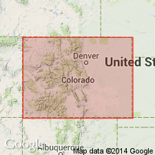
- Areal extent
- Overview
- AAPG geologic province:
-
- San Luis basin
- San Juan Mountains province
- San Juan basin
Summary:
Masonic Park Tuff. Fragmentary evidence suggests Mount Hope caldera was the source. Probably concurrent with Sheep Mountain Andesite; succeeded by the Fish Canyon Tuff. Lower sheet of Masonic Park Tuff has been recognized only within 10 to 15 km of the caldera, but the upper sheet extends west of the caldera to the margin of the San Luis Valley, 50 km east, and into New Mexico, 75 miles (approx. 120 km) southeast. Areal extent of upper member in southwestern Colorado shown on distribution map; present in southern Saguache, Rio Grande, Conejos, Mineral and Archuleta Counties (San Luis basin, San Juan Mountain province, and San Juan basin). Upper member had an estimated volume of more than 500 cubic km. Age is 28.2 m.y.
Source: Modified from GNU records (USGS DDS-6; Denver GNULEX).
- Usage in publication:
-
- Masonic Park Tuff*
- Modifications:
-
- Revised
- AAPG geologic province:
-
- San Luis basin
- San Juan Mountains province
Summary:
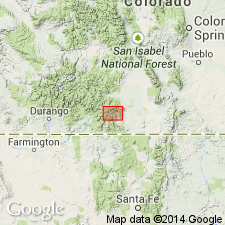
Rocks previously referred to as "lower rhyolitic unit" of Masonic Park by Dungan and others (1989, New Mexico Bur. Mines and Min. Res. Mem. 46) are reassigned to newly named South Fork Tuff of Treasure Mountain Group (rank raised). Rocks previously assigned to upper part of Masonic Park are reassigned to newly named Chiquito Peak Tuff. In Turkey Creek, lower unit mapped as Masonic Park is instead distal La Jara Canyon Tuff (rank raised) of Treasure Mountain. At Goose Creek two units previously mapped as Masonic Park is an Oligocene landslide deposit. Revised Masonic Park is exposed only locally in southeastern part of San Juan volcanic field: along Rio Grande and its tributaries north and west of South Fork (includes type locality), from Wolf Creek Pass south to Saddle Mountain, and northward to headwaters of Goose Creek; also exposed locally beneath younger formations (mainly Fish Canyon Tuff), as far west as Williams Creek south of Continental Divide, and as far north as Bristol Head (all in Rio Grande and Mineral Cos, CO, San Luis basin and San Juan Mountain province). Only along Highway 160 corridor is Masonic Park overlain by Chiquito Peak Tuff (new) of Treasure Mountain; over wide area unit rests directly on lavas and associated rocks of Conejos Formation; overlies lower tuffs of Treasure Mountain only in Turkey and Wolf Creek drainages. Thickness at type is 350 m with no base exposed; 175 m thick just north of South Fork; within two km to southeast unit wedges out to zero thickness.
Source: GNU records (USGS DDS-6; Denver GNULEX).
For more information, please contact Nancy Stamm, Geologic Names Committee Secretary.
Asterisk (*) indicates published by U.S. Geological Survey authors.
"No current usage" (†) implies that a name has been abandoned or has fallen into disuse. Former usage and, if known, replacement name given in parentheses ( ).
Slash (/) indicates name conflicts with nomenclatural guidelines (CSN, 1933; ACSN, 1961, 1970; NACSN, 1983, 2005, 2021). May be explained within brackets ([ ]).