

- Usage in publication:
-
- Maple Canyon Formation*
- Modifications:
-
- Original reference
- Dominant lithology:
-
- Argillite
- Arkose
- Conglomerate
- AAPG geologic province:
-
- Northern Rocky Mountain region
Summary:
Pg. 587-589. Maple Canyon Formation. Present in Huntsville area, Weber County, Utah. Divided into 3 informal members (ascending): (1) argillite member, an olive-drab to locally gray, thin-bedded, silty, typically phylitic, locally schistose argillite containing 1 or more beds of greenish-gray arkosic sandstone, thickness about 500 feet; (2) arkose member, a thick-bedded, massive, very fine-grained arkosic sandstone, thickness 500 to 1,000 feet; and (3) conglomerate member, comprising of two conglomerates (or locally, quartzites) and an intervening 10- to 100-foot-thick, olive-drab, laminated argillite, thickness 60 to 500 feet. Total thickness at type locality is 460 m [approx. 1,510 feet]. Is the oldest unit in the Huntsville area. Lower contact not exposed; underlies Kelley Canyon Formation (new). Age is late Precambrian (Precambrian Z). (Maple Canyon Formation adopted by the USGS.)
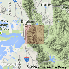
Type locality: near mouth [and/or?] on northwest side of Maple Canyon, [4 km (approx. 2.5 mi) northeast?] of Hunstville, from N/2 sec. 9 to center sec. 4, T. 6 N., R. 2 E., Weber Co., UT (Northern Rocky Mountain region). Named from exposures in Maple Canyon, [about 6 mi east?] of Huntsville.
[Discrepancy: GNU records (USGS DDS-6; Denver GNULEX) state type locality is "near mouth of Maple Canyon" and formation was named from exposures "6 mi east" of Huntsville. US geologic names lexicon (USGS Bull. 1520, p. 193) states type locality is "on northwest side of Maple Canyon" and is " 4 km (approx. 2.5 mi) northeast" of Huntsville. --unresolved.]
Source: Changes in stratigraphic nomenclature, 1971 (USGS Bull. 1372-A, p. A12-A13); GNU records (USGS DDS-6; Denver GNULEX, Menlo GNULEX); US geologic names lexicon (USGS Bull. 1520, p. 193).
- Usage in publication:
-
- Maple Canyon Formation*
- Modifications:
-
- Age modified
- AAPG geologic province:
-
- Wasatch uplift
Summary:
Age of the Maple Canyon Formation is revised from Precambrian Z --to-- Late Proterozoic.
Source: GNU records (USGS DDS-6; Menlo GNULEX).
For more information, please contact Nancy Stamm, Geologic Names Committee Secretary.
Asterisk (*) indicates published by U.S. Geological Survey authors.
"No current usage" (†) implies that a name has been abandoned or has fallen into disuse. Former usage and, if known, replacement name given in parentheses ( ).
Slash (/) indicates name conflicts with nomenclatural guidelines (CSN, 1933; ACSN, 1961, 1970; NACSN, 1983, 2005, 2021). May be explained within brackets ([ ]).