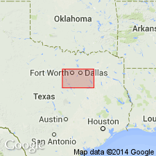
- Usage in publication:
-
- Main Street Limestone
- Modifications:
-
- Areal extent
- AAPG geologic province:
-
- Fort Worth syncline
- Ouachita folded belt
- Strawn basin
Summary:
Main Street Limestone. Medium-grained, chalky, some 6- to 8-foot units of calcareous shale, thin-bedded to massive, distinctly bedded to wavy bedded and nodular, yellowish gray; weathers light gray to white. Thickness 20 to 35 feet, thins northward. Lies above Pawpaw Formation and below Grayson Marl. Age is Early Cretaceous.
Not separately mapped. Grayson Marl and Main Street Limestone [undifferentiated] mapped [in Denton, Hill, Johnson, and Tarrant Cos., eastern TX].
Source: Publication.

- Usage in publication:
-
- Main Street Limestone
- Modifications:
-
- Areal extent
- Dominant lithology:
-
- Limestone
- Marl
- AAPG geologic province:
-
- Fort Worth syncline
- Ouachita folded belt
- South Oklahoma folded belt
Summary:
Pamphlet [p. 4]. Main Street Limestone. Yellowish-gray, light-brown, weathers to dull grayish-yellow, coarse-grained, well-indurated, thick-bedded, some interbedded thin marl. Thickness 10 to 20 feet. Lies above Pawpaw Formation and below Grayson Marl. [Age is Early Cretaceous.]
Not separately mapped. Main Street Limestone mapped undifferentiated with Grayson Marl in Texas, [in Red River area and southward to southern boundary of map sheet, in Cooke, Denton, and Grayson Cos.].
[On previous edition of map (1967), Main Street Limestone separately mapped. Rocks just southeast of Marietta, Love Co., OK, that were included in Main Street Limestone, are reallocated to older Pawpaw Sandstone Member of Bokchito Formation on the revised 1991 ed.]
Source: Publication.
For more information, please contact Nancy Stamm, Geologic Names Committee Secretary.
Asterisk (*) indicates published by U.S. Geological Survey authors.
"No current usage" (†) implies that a name has been abandoned or has fallen into disuse. Former usage and, if known, replacement name given in parentheses ( ).
Slash (/) indicates name conflicts with nomenclatural guidelines (CSN, 1933; ACSN, 1961, 1970; NACSN, 1983, 2005, 2021). May be explained within brackets ([ ]).

