

- Usage in publication:
-
- Lusk formation
- Modifications:
-
- Named
- Dominant lithology:
-
- Shale
- Sandstone
- AAPG geologic province:
-
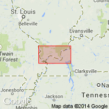
- Illinois basin
Summary:
Lusk formation named as basal formation in Caseyville group (rank raised). Occurs at base of Pennsylvanian throughout most of southern IL. Consists principally of sandy shale and shaly sandstone with more or less massive locally developed sandstones, one or more thin coals and zones of poorly preserved marine fossils. Maximum thickness 200 ft in type locality; commonly less than 100 ft. Underlies Battery Rock formation. Name Wayside was formerly applied to strata included in Lusk.
Source: GNU records (USGS DDS-6; Reston GNULEX).

- Usage in publication:
-
- Lusk shale member
- Modifications:
-
- Revised
- AAPG geologic province:
-
- Illinois basin
Summary:
Pg. 29, 30, 44 (table 1), 61-62, pl. 1. Lusk shale member of Caseyville formation of McCormick group (new). Occurs below Battery Rock sandstone member. Thickness 49 feet at type section of Caseyville; about 141 feet at reference section of Caseyville. Lusk and Drury shale members are composite units, but until subdivided, names are useful and are retained. Age is Pennsylvanian. Presentation of new rock-stratigraphic classification of Pennsylvanian strata in Illinois.
Source: US geologic names lexicon (USGS Bull. 1200, p. 2278).

- Usage in publication:
-
- Lusk†
- Modifications:
-
- Abandoned
- AAPG geologic province:
-
- Illinois basin
Summary:
Mapping in southern IL has shown that the type Lusk and the type Wayside are lithologically similar units and are stratigraphically equivalent. The name Lusk is abandoned in favor of Wayside, which has priority.
Source: GNU records (USGS DDS-6; Reston GNULEX).
For more information, please contact Nancy Stamm, Geologic Names Committee Secretary.
Asterisk (*) indicates published by U.S. Geological Survey authors.
"No current usage" (†) implies that a name has been abandoned or has fallen into disuse. Former usage and, if known, replacement name given in parentheses ( ).
Slash (/) indicates name conflicts with nomenclatural guidelines (CSN, 1933; ACSN, 1961, 1970; NACSN, 1983, 2005, 2021). May be explained within brackets ([ ]).