

- Usage in publication:
-
- Luis Lopez Formation
- Modifications:
-
- Overview
- AAPG geologic province:
-
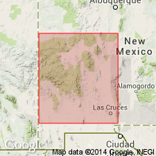
- Orogrande basin
Summary:
Type area designated at south end of Luis Lopez manganese district, 11 mi southwest of Socorro and 7 mi southwest of village of Luis Lopez, east side Chupadera Mountains from 2.5 mi north of Nogal Canyon to 3.3 mi south of Nogal Canyon in secs 20, 29, 31, 32, T4S, R1W, and secs 4, 5, 6, 8, 9, T5S, R1W, Socorro Co, NM, Orogrande basin. Originally named for exposures at north end Chupadera Range but stratigraphic relationships in Nogal Canyon area are better. Is known in Socorro Peak, Chupadera and Magdalena Mountains. Is the cauldron-fill unit of the Socorro cauldron. Includes rhyolite domes and flows, local ash-flow tuffs, volcaniclastic rocks, breccias, andesite flows and intrusives. Includes the informal rhyolites of Bianchi Ranch and of Hardy Ridge. Above Hells Mesa Tuff (revised) and below La Jencia Tuff (named). Has not been dated.
Source: GNU records (USGS DDS-6; Denver GNULEX).
For more information, please contact Nancy Stamm, Geologic Names Committee Secretary.
Asterisk (*) indicates published by U.S. Geological Survey authors.
"No current usage" (†) implies that a name has been abandoned or has fallen into disuse. Former usage and, if known, replacement name given in parentheses ( ).
Slash (/) indicates name conflicts with nomenclatural guidelines (CSN, 1933; ACSN, 1961, 1970; NACSN, 1983, 2005, 2021). May be explained within brackets ([ ]).