The National Geologic Map Database is migrating to a new infrastructure. We apologize for any service disruptions during this process.
|
|---|


- Usage in publication:
-
- Logan Gulch Member*
- Modifications:
-
- Original reference
- Dominant lithology:
-
- Breccia
- Shale
- Siltstone
- Limestone
- AAPG geologic province:
-
- Montana folded belt
Summary:
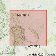
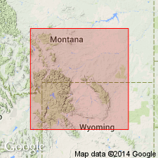
Pg. N2 (fig. 1), N8 (fig. 3), N10-N12; 1962, Billings Geol. Soc. Gdbk., 13th Ann. Field Conf., p. 47-50. Logan Gulch Member of Three Forks Formation. Name applied to lower evaporitic nonfossiliferous part of Three Forks Formation in western Montana and northwestern Wyoming. Underlies Trident Member (new); overlies Jefferson Formation. At Logan, Montana, where it is 111 feet thick, consists of yellowish-gray and grayish-red argillaceous limestone breccia and shale breccia; interbedded in basal 12 feet with dolomitic shale and siltstone and silty dolomite and capped by an 8- to 22-foot lenticular bed of brownish-gray limestone and limestone breccia. Section at Logan is characteristic of member in Bridger Range and areas to west and north. Changes facies across northern Gallatin Range and its lithologic character is somewhat different but still recognizable as evaporitic in Beartooth Mountains. Subsurface name Potlatch proposed by Sandberg and Hammond (1958) is herein abandoned in favor of Logan Gulch Member. Member is lithologically and stratigraphically identical with outcropping Potlatch Member and equivalent to most of carbonate Three Forks Formation, as used in southwestern Montana by McMannis (1962). Recommended herein that this usage be discarded in favor of Logan Gulch. Rau (1962) proposed another name [London Hills] for lower part of outcropping Three Forks Formation. However the member [Logan Hills] crosses lower boundary of Three Forks at Logan and several other localities and cannot be considered an equivalent of Logan Gulch Member. Age is Late Devonian.
Type section: included in type section of Three Forks, as given by Sandberg (1962), in gulch and on bluffs at north side of Gallatin River, northeast of Logan, in S/2 S/4 sec. 25, T. 2 N., R. 2 E., Gallatin Co., MT. Named from exposures in Logan Gulch, near Logan.
Source: US geologic names lexicon (USGS Bull. 1350, p. 433-434).
- Usage in publication:
-
- Logan Gulch Member*
- Modifications:
-
- Overview
- Areal extent
- AAPG geologic province:
-
- Montana folded belt
- Yellowstone province
- Bighorn basin
Summary:
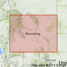
Lowermost member of Three Forks Formation. Cross section shows southeast truncation of Three Forks by regional unconformity beneath dark shale unit of Devonian and Mississippian age. Logan Gulch is present at Logan, MT, Gallatin Range, Beartooth Mountains and Absaroka Range in Montana folded belt and Yellowstone provinces and is truncated just east of southeast flank of Beartooth Mountains, in northwest Bighorn basin, WY. In WY, Three Forks consists mostly of Logan Gulch with overlying Trident Member of Three Forks extending several miles into northwest corner of State. Figure 2 shows eastern limit of Three Forks. [Though not stated as such, this limit line, in places, could be inferred to be eastern limit of Logan Gulch]. At measured sections in Beartooth Mountains, unit is 15 ft thick; 56 ft thick at section in Absaroka Range. Conformably overlies Birdbear Member of Jefferson Formation. Correlation chart. Late Devonian age.
Source: GNU records (USGS DDS-6; Denver GNULEX).
- Usage in publication:
-
- Logan Gulch Member*
- Modifications:
-
- Revised
- AAPG geologic province:
-
- Yellowstone province
- Bighorn basin
- Central Montana uplift
Summary:
As lower member of Three Forks Formation unconformably underlies the lower tongue of the newly named Cottonwood Canyon Member of the Madison Limestone in northern and west-central WY in Yellowstone province and the Bighorn basin and in southern MT on the Central Montana uplift. Assigned to the Late Devonian.
Source: GNU records (USGS DDS-6; Denver GNULEX).
- Usage in publication:
-
- Logan Gulch Member*
- Modifications:
-
- Areal extent
- AAPG geologic province:
-
- Montana folded belt
Summary:
As lower member [of Late Devonian age] of Three Forks Formation, is identified in the Bell-McKenzie Divide section (T11S, R10W), Beaverhead Co, MT in the Montana folded belt province.
Source: GNU records (USGS DDS-6; Denver GNULEX).
For more information, please contact Nancy Stamm, Geologic Names Committee Secretary.
Asterisk (*) indicates published by U.S. Geological Survey authors.
"No current usage" (†) implies that a name has been abandoned or has fallen into disuse. Former usage and, if known, replacement name given in parentheses ( ).
Slash (/) indicates name conflicts with nomenclatural guidelines (CSN, 1933; ACSN, 1961, 1970; NACSN, 1983, 2005, 2021). May be explained within brackets ([ ]).