The National Geologic Map Database is migrating to a new infrastructure. We apologize for any service disruptions during this process.
|
|---|


- Usage in publication:
-
- Kinter Formation*
- Modifications:
-
- Named
- Geochronologic dating
- Dominant lithology:
-
- Sandstone
- Breccia
- Tuff
- AAPG geologic province:
-
- Basin-and-Range province
Summary:
Pg. H33-H37. Kinter Formation. At type, divided into: (1) lower member, light-brown and greenish-gray coarse to fine breccia with tongues of sandstone and mudstone, 1,400 feet thick; and (2) upper member, gray, arkosic, pebbly, and tuffaceous sandstone, mudstone, tuff, and conglomerate, 2,180 feet thick. Total thickness at type 3,580 feet. Members can be traced northward into southern Laguna Mountains. Also exposed in narrow belt along south flank of Imperial Dam and in southwestern Chocolate Mountains, California. Data from subsurface wells show unit unconformably(?) underlies Bouse Formation. Overlies Tertiary volcanic rocks. Age is Miocene based on K-Ar age of 23 +/-2 Ma and stratigraphic evidence. Report includes geologic map of Yuma.
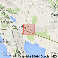
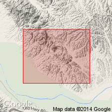
Type section: directly south of Wellton-Mohawk Canal, 1.7 km east to 1.3 km south of McPhaul Bridge, and about 11.2 km southeast of Laguna Dam, in secs. 3, 9, 10, and 11, T. 8 S., R. 21 W., Gila and Salt River Meridian, Yuma Co., AZ. Named from Southern Pacific RR siding at north end of Gila Mountains.
Source: GNU records (USGS DDS-6; Menlo GNULEX); US geologic names lexicon (USGS Bull. 1520, p. 167).

- Usage in publication:
-
- Kinter Formation*
- Modifications:
-
- Geochronologic dating
- AAPG geologic province:
-
- Basin-and-Range province
Summary:
Pg. 6, geologic time scale (inside front cover). Kinter Formation. Sample from a 0.6- to 1.2-m-thick bed of pink bentonitic ash in lower part of upper member of Kinter Formation, in Laguna Mountains, in sec. 5, T. 8 S., R. 21 W., Lat. 32 deg. 45 min. 58 sec. N., Long. 114 deg. 26 min. 10 sec. W., Laguna Dam quadrangle, Yuma County, Arizona, yielded a K-Ar age of 24.2 +/-1.2 Ma (biotite); previously published age 23 Ma (Olmstead and others, 1973, USGS Prof. Paper 486-H). Sample from a tuff underlying the Kinter in same area, yielded a K-Ar age of 26.9 +/-1.0 Ma (biotite); previously published age 26.3 Ma (Olmstead and others, 1973). Published ages recalculated using decay constants of Steiger and Jager, 1977 (Earth Planet. Sci. Letters, v. 36, p. 359-362). [Oligocene, based on time scale of Berggren, 1972, Lethaia, v. 5, no. 2, p. 195-215.]
Source: Publication.
- Usage in publication:
-
- Kinter Formation*
- Modifications:
-
- Age modified
- AAPG geologic province:
-
- Basin-and-Range province
Summary:
Kinter Formation. Unit age revised from Miocene --to-- late Oligocene(?) and early Miocene based on K-Ar ages of 24.3 +/-1.2 Ma and 22.5 +/-0.7 Ma (and early Miocene camel (bones) from unit).
Source: GNU records (USGS DDS-6; Menlo GNULEX).
For more information, please contact Nancy Stamm, Geologic Names Committee Secretary.
Asterisk (*) indicates published by U.S. Geological Survey authors.
"No current usage" (†) implies that a name has been abandoned or has fallen into disuse. Former usage and, if known, replacement name given in parentheses ( ).
Slash (/) indicates name conflicts with nomenclatural guidelines (CSN, 1933; ACSN, 1961, 1970; NACSN, 1983, 2005, 2021). May be explained within brackets ([ ]).