

- Usage in publication:
-
- Kathul Graywacke*
- Modifications:
-
- Named
- Dominant lithology:
-
- Sandstone
- Conglomerate
- AAPG geologic province:
-
- Alaska East-Central region
Summary:
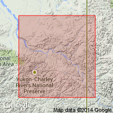
Named as top of three units of Kandik Group. Type section designated as exposures on middle to upper south slope of Kathul Mountain, north of Yukon River, from 1.5 to 0.8 km southeast of bench mark 3122 (Kat) [sec.18] T6N R27E, Charley River B-3 quad, northeast AK. Composed of greenish-gray, medium- to coarse-grained, poorly sorted sandstone and conglomerate that grades upward to thin beds of siltstone and argillite in rhythmical sets. Thickness is 450 m; range is 450 to 1000 m. Unconformably overlies Biederman Argillite (new) or older rocks. Unconformably underlies unnamed sedimentary rocks. Age is Early Cretaceous.
Source: GNU records (USGS DDS-6; Menlo GNULEX).
For more information, please contact Nancy Stamm, Geologic Names Committee Secretary.
Asterisk (*) indicates published by U.S. Geological Survey authors.
"No current usage" (†) implies that a name has been abandoned or has fallen into disuse. Former usage and, if known, replacement name given in parentheses ( ).
Slash (/) indicates name conflicts with nomenclatural guidelines (CSN, 1933; ACSN, 1961, 1970; NACSN, 1983, 2005, 2021). May be explained within brackets ([ ]).