The National Geologic Map Database is migrating to a new infrastructure. We apologize for any service disruptions during this process.
|
|---|


- Usage in publication:
-
- Janesville shale*
- Modifications:
-
- Original reference
- Dominant lithology:
-
- Shale
- Limestone
- Sandstone
- Coal
- AAPG geologic province:
-
- Cherokee basin
Summary:
Pg. 2273, 2274 (fig. 1). Janesville shale of Admire group. Defined to include strata between Foraker limestone above and Falls City limestone below. Average thickness 75 feet. Includes (ascending) West Branch shale, Five Point limestone, and Hamlin shale members. Age is Permian.
Type section: in cut on east-west road in SW/4 SE/4 sec. 23, T. 23 S., R. 10 E., Greenwood Co., southeastern KS. Named from Janesville Twp., Greenwood Co., southeastern KS.
Source: US geologic names lexicon (USGS Bull. 1200, p. 1911).
- Usage in publication:
-
- Janesville Shale*
- Modifications:
-
- Biostratigraphic dating
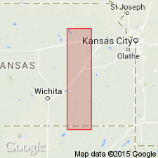
- Areal extent
- AAPG geologic province:
-
- Chautauqua platform
- Cherokee basin
- Forest City basin
- Nemaha anticline
Summary:
Janesville Shale of Admire Group. Includes (ascending) West Branch Shale Member, Five Point Limestone Member, and Hamlin Shale Member. Overlies Falls City Limestone of Admire and underlies Foraker Limestone of Coucil Grove Group. Interpreted to be nearshore marine and land deposits. Age is Late Pennsylvanian (late Gzhelian; STREPTOGNATHODUS BELLUS and S. FLEXUOSUS conodont zones).
Described from measured sections in Chautauqua, Cowley, Greenwood, Pottawatomie, and Wabaunsee Counties, eastern Kansas, and Osage County, northern Oklahoma. (Locs. 1, 2, 3, 4, A1, A10, A11, A13, A16, A17, A19, A25, A26.)
Source: Publication.
For more information, please contact Nancy Stamm, Geologic Names Committee Secretary.
Asterisk (*) indicates published by U.S. Geological Survey authors.
"No current usage" (†) implies that a name has been abandoned or has fallen into disuse. Former usage and, if known, replacement name given in parentheses ( ).
Slash (/) indicates name conflicts with nomenclatural guidelines (CSN, 1933; ACSN, 1961, 1970; NACSN, 1983, 2005, 2021). May be explained within brackets ([ ]).