

- Usage in publication:
-
- Jacobs Ranch Formation
- Modifications:
-
- Named
- Dominant lithology:
-
- Siltstone
- Sandstone
- Conglomerate
- AAPG geologic province:
-
- Plateau sedimentary province
Summary:
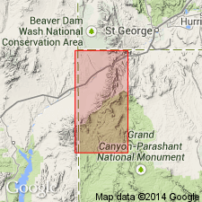
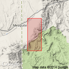
Named for ranch in area of outcrop. No type locality designated. Occurs as a band about 4 mi long and up to 1,000 feet wide in unsurveyed secs 5, 6 and 7, T37N, R15W and in surveyed sec 32, T38N, R15W, Mohave Co, AZ, Plateau sedimentary province. Forms hummocky terrain of reddish-brown to pale-yellow, sandy slopes, and swales containing light-gray to buff silty soil. Basal conglomerate overlain by up to 285 feet of clastic sediments consisting of light-gray to pink-gray siltstone; reddish-brown, thin-bedded, sandy siltstone with some interbedded 1 to 2 feet beds of massive yellow-brown sandstone; and, in lower half of unit, buff to gray, silty sandstone, locally cross-bedded, containing a few thin, chert-pebble conglomerate beds. Underlies Cottonwood Wash Formation (new) with an angular? unconformity; overlies Navajo Sandstone with an angular? unconformity. Measured section. Stratigraphic chart. Based on stratigraphic position and lithology, unit is probably equivalent to Iron Springs Formation of southwest UT which has been correlated with Willow Tank Formation and Baseline Sandstone in Muddy Mountains, NV, 40 mi to west. Assigned Cretaceous? age.
Source: GNU records (USGS DDS-6; Denver GNULEX).
- Usage in publication:
-
- Jacobs Ranch Formation
- Modifications:
-
- Not used
Summary:
Not used in northwestern Mohave Co, AZ, Plateau sedimentary province. Replaced by Willow Tank Formation because of close lithologic similarity to Willow Tank in northern Muddy Mountains, NV. Name Willow Tank is more widely used than Jacobs Ranch.
Source: GNU records (USGS DDS-6; Denver GNULEX).
For more information, please contact Nancy Stamm, Geologic Names Committee Secretary.
Asterisk (*) indicates published by U.S. Geological Survey authors.
"No current usage" (†) implies that a name has been abandoned or has fallen into disuse. Former usage and, if known, replacement name given in parentheses ( ).
Slash (/) indicates name conflicts with nomenclatural guidelines (CSN, 1933; ACSN, 1961, 1970; NACSN, 1983, 2005, 2021). May be explained within brackets ([ ]).