

- Usage in publication:
-
- Ilmon basalt
- Modifications:
-
- Named
- Dominant lithology:
-
- Basalt
- AAPG geologic province:
-
- San Joaquin basin
Summary:
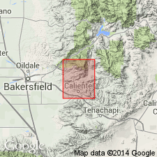
Is traceable through series of isolated outcrops from point 2 mi west of Ilmon Station northwestward about 3 mi to west border of Breckenridge 15' quad, Kern Co, CA. Consists of highly vesicular, dark-brown, massive basalt. Ranges in thickness from one in. to 100 feet. Conformably overlies Walker Formation in Caliente Canyon. Underlies Bena gravel (new). About 3 mi northwest of Bena just beyond border of quad, where Ilmon is about 15 feet thick, unit separates Walker formation below from Freeman-Jewett shale [Freeman silt] above. Age is probably early Miocene (Zemorrian) based on stratigraphic relations.
Source: GNU records (USGS DDS-6; Menlo GNULEX).
- Usage in publication:
-
- Ilmon Basalt*
- Modifications:
-
- Adopted
- AAPG geologic province:
-
- San Joaquin basin
Summary:
Ilmon Basalt of Dibblee and Chesterman (1953) is here adopted. Type locality designated in lower Walker Basin Creek at its confluence with Caliente Canyon, Breckenridge Mountain 15' quad, Kern Co, CA. Although unit is apparently concordant over Walker Formation there was a hiatus between. Unconformably underlies Bena Gravel. Age is early Miocene based on its stratigraphic position.
Source: GNU records (USGS DDS-6; Menlo GNULEX).
For more information, please contact Nancy Stamm, Geologic Names Committee Secretary.
Asterisk (*) indicates published by U.S. Geological Survey authors.
"No current usage" (†) implies that a name has been abandoned or has fallen into disuse. Former usage and, if known, replacement name given in parentheses ( ).
Slash (/) indicates name conflicts with nomenclatural guidelines (CSN, 1933; ACSN, 1961, 1970; NACSN, 1983, 2005, 2021). May be explained within brackets ([ ]).