The National Geologic Map Database is migrating to a new infrastructure. We apologize for any service disruptions during this process.
|
|---|


- Usage in publication:
-
- Ibex limestone
- Modifications:
-
- Original reference
- AAPG geologic province:
-
- Bend arch
Summary:
Pg. 5. Ibex limestone. Proposed to replace preoccupied "Dothan" limestone. Normally 2 to 3 feet thick, between clays of Watts Creek shale. Resistant bed; outcrops characterized by large slabs at various angles.
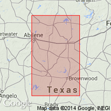
Typical outcrops occur 500 ft east of northwest corner of Blind Asylum Survey No. 51, 0.5 mi southeast of Ibex townsite, and also just north and west of Ibex field along Hubbard Creek. Named from Ibex oil field in east-central Shackelford Co., in north-central TX.
Source: US geologic names lexicon (USGS Bull. 1200, p. 1851).

- Usage in publication:
-
- Ibex Limestone [unranked]
- Modifications:
-
- Mapped 1:250k
- Dominant lithology:
-
- Limestone
- AAPG geologic province:
-
- Bend arch
Summary:
Ibex Limestone ("Dothan Limestone") [unranked] in Moran Formation of Cisco Group. Fine-grained, in part sandy, bioclastic, locally limestone conglomerate lenses, gray to brown, PINNA and algae scarce. Thickness 4 to 6 feet near southern edge of map, commonly 1 foot thick in Shackelford County.
Mapped in Brown, Callahan, Coleman, Shackelford, and Stephens Cos., central northern TX.
Source: Publication.
For more information, please contact Nancy Stamm, Geologic Names Committee Secretary.
Asterisk (*) indicates published by U.S. Geological Survey authors.
"No current usage" (†) implies that a name has been abandoned or has fallen into disuse. Former usage and, if known, replacement name given in parentheses ( ).
Slash (/) indicates name conflicts with nomenclatural guidelines (CSN, 1933; ACSN, 1961, 1970; NACSN, 1983, 2005, 2021). May be explained within brackets ([ ]).