The National Geologic Map Database is migrating to a new infrastructure. We apologize for any service disruptions during this process.
|
|---|


- Usage in publication:
-
- Hunter Valley cherts
- Modifications:
-
- First used
- Dominant lithology:
-
- Chert
- Tuff
- AAPG geologic province:
-
- Sierra Nevada province
Summary:
On Merced River and southward into Indian Gulch 15-min quadrangle, Mariposa County, California, Hunter Valley cherts and tuffs, 1,500 feet thick, included in Tuolumne [later Amador] group. Underlie Penon Blanco agglomerates (new). Age is probably early Mesozoic.
Source: GNU records (USGS DDS-6; Menlo GNULEX).
- Usage in publication:
-
- Hunter Valley cherts
- Modifications:
-
- Named
- Dominant lithology:
-
- Chert
- Slate
- Tuff
- AAPG geologic province:
-
- Sierra Nevada province
Summary:
Pg. 283, 303-323. Hunter Valley cherts. Assigned to Amador group. Consist of red, chocolate, gray, green, and black radiolarian chert, both massive and thin-bedded with partings of red, lilac, purple, chocolate, gray-green, and black slates and tuffaceous slates; schistose green tuffs and thin flows; impure cherts and siliceous mudstones near top of section. In Merced River section, Hunter Valley cherts overlie pillow basalts and underlie Penon Blanco volcanics. Thickness 950 feet. Equivalent to part of Cosumnes formation. Age of Amador group is believed to be late Middle to early Late Jurassic.
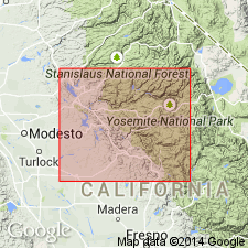
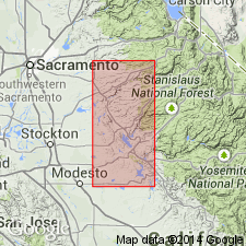
Occurs along Merced River in southern type section of Amador group. [Name probably derived from Hunter Valley in eastern part of Coulterville 15-min quadrangle, Mariposa Co., CA.]
[Misprint: GNU records (USGS DDS-6; Menlo GNULEX, Sept. 20, 1988) state thickness is 90 feet; should be 950 feet.]
Source: US geologic names lexicon (USGS Bull. 1200, p. 1842); GNU records (USGS DDS-6; Menlo GNULEX).
- Usage in publication:
-
- Hunter Valley cherts
- Modifications:
-
- Not used
- AAPG geologic province:
-
- Sierra Nevada province
Summary:
The five formations of the Amador Group (Taliaferro, 1943, California Div. Mines Bull., no. 125) in Merced River area are not used in this report [except for Penon Blanco volcanics].
[Author does not capitalize rank terms; however, units are considered formal.]
Source: Modified from GNU records (USGS DDS-6; Menlo GNULEX).
For more information, please contact Nancy Stamm, Geologic Names Committee Secretary.
Asterisk (*) indicates published by U.S. Geological Survey authors.
"No current usage" (†) implies that a name has been abandoned or has fallen into disuse. Former usage and, if known, replacement name given in parentheses ( ).
Slash (/) indicates name conflicts with nomenclatural guidelines (CSN, 1933; ACSN, 1961, 1970; NACSN, 1983, 2005, 2021). May be explained within brackets ([ ]).