

- Usage in publication:
-
- Huckleberry Ridge Tuff*
- Modifications:
-
- Original reference
- Dominant lithology:
-
- Tuff
- AAPG geologic province:
-
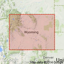
- Yellowstone province
Summary:
Pg. B3, B4 (fig. 2), B5, B6 (table 1). Huckleberry Ridge Tuff, oldest ash-flow sheet of Yellowstone Group (rank raised). Consists mainly of welded phenocryst-rich rhyolitic ash-flow tuff forming a single compound cooling unit. Divided into 3 informal members based on changes in welding and minor variations in phenocryst content: (1) lower member, about 45 m thick; (2) middle member, about 30 m thick; (3) upper member, about 95 m thick. Total thickness up to 300 m in some places; about 170 m at type. Exposed around margins of park and south to Jackson Hole; north into valley of Gallatin River and as far as West Fork; and west into Island Park area to edge of younger lavas of Snake River Plain, Idaho. West of park, commonly underlies Mesa Falls Tuff (new); most other areas underlies Lava Creek Tuff (new). At type overlies Cretaceous sandstones and shales; top is eroded. [Age is Pliocene.] K-Ar dating of sanidine indicates an age of 2 m.y. (citing J.D. Obradovich, written commun., 1970). Is part of the first volcanic cycle of the Quaternary Yellowstone plateau. Report includes stratigraphic table, cross section.
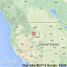
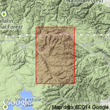
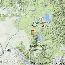
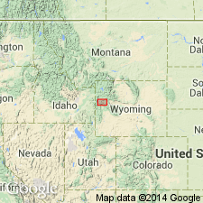
Type section: cliff exposure at head of large landslide 1.8 km N. 10 deg. E. of Snake River bridge at Flagg Ranch on highway 3 km south of South Entrance of Yellowstone National Park, Teton Co., WY (Yellowstone province). Named from Huckleberry Ridge, a topographic crest just south of park boundary and north of Jackson Lake.
Source: Publication; US geologic names lexicon (USGS Bull. 1520, p. 144).
- Usage in publication:
-
- Huckleberry Ridge Tuff*
- Modifications:
-
- Geochronologic dating
- Areal extent
- AAPG geologic province:
-
- Yellowstone province
Summary:
Recent petrographic and chemical studies of ash samples called Pearlette have shown that there are at least three different ash beds on the Great Plains and Rocky Mountain area of closely related petrographic and properties that are related to the Yellowstone Tuff. Pearlette type O identified at Onion Creek, SE1/4 NE1/4 sec 26, T24S, R24E, Grand Co, UT, Paradox basin, has 0.7 +/-0.2 m.y. age, and at three localities in Meade Co, KS, Anadarko basin, has 0.6 +/-0.07 to 0.9 +/-0.25 m.y. age. Type O correlates with Lava Creek Tuff of Yellowstone area WY. Pearlette type S is correlated with the Mesa Falls Tuff of Yellowstone area of 1.2 m.y. age. Zircons from type S not dated because of small size and paucity. Pearlette type B identified at Cudahy ash Mine, Meade Co, KS in the Anadarko basin has an age of 2.0 m.y. and is correlated with Huckleberry Ridge Tuff of Yellowstone National Park, WY, Yellowstone province.
Source: GNU records (USGS DDS-6; Denver GNULEX).
- Usage in publication:
-
- Huckleberry Ridge Tuff*
- Modifications:
-
- Geochronologic dating
- Areal extent
- AAPG geologic province:
-
- Yellowstone province
Summary:
A tuff in the headwaters of the Lamar River previously assigned to the Huckleberry Ridge Tuff has been dated by zircons from the tuff and has chemical and petrographic characteristics that indicate it is not Huckleberry Ridge. Fission track ages range from 0.56 +/-0.24 to 1.1 +/-0.8 m.y. Tuff is probably Lava Creek Tuff.
Source: GNU records (USGS DDS-6; Denver GNULEX).
- Usage in publication:
-
- Huckleberry Ridge Tuff*
- Modifications:
-
- Geochronologic dating
- Areal extent
- AAPG geologic province:
-
- Yellowstone province
- Snake River basin
Summary:
Pg. C8. Huckleberry Ridge Tuff has a K-Ar age of 1.9 Ma (Christiansen and Blank, 1972; J.D. Obradovich, written commun., 1974); considered Pleistocene. Overlies Pliocene Conant Creek Tuff (new) in northern part of Teton Range and Jackson Hole, Wyoming.
Source: Publication.
- Usage in publication:
-
- Huckleberry Ridge Tuff*
- Modifications:
-
- Age modified
- AAPG geologic province:
-
- Yellowstone province
- Bighorn basin
Summary:
Using new decay constants, age recalculated to 2.02 +/-0.8 m.y. thereby changing age of Huckleberry Ridge Tuff of Yellowstone Group from Pleistocene to Pliocene. Occurs in Yellowstone area, Teton Range, in the Yellowstone province, and Absaroka, Washakie, and Gros Ventre Ranges, in the Bighorn basin.
Source: GNU records (USGS DDS-6; Denver GNULEX).
- Usage in publication:
-
- Huckleberry Ridge ash bed (informal)*
- Modifications:
-
- Geochronologic dating
- Areal extent
- AAPG geologic province:
-
- Anadarko basin
- Central Montana uplift
- Central Western Overthrust
- Forest City basin
- Great Basin province
- Mojave basin
- Permian basin
- Sedgwick basin
Summary:
Huckleberry Ridge ash bed. The informal designation for ash that is the downwind equivalent of Huckleberry Ridge Tuff of Yellowstone Group of the Yellowstone National Park area, Wyoming and Idaho. Previously called Pearlette type B ash. Age is Pliocene, based on K-Ar age (sanidine) of 2.02 Ma for Huckleberry Ridge Tuff (J.D. Obradovich, written commun., 1979; calculated using current decay constants of Steiger and Jager, 1977); Plio-Pliocene boundary placed at 1.8 Ma.
Huckleberry Ridge ash bed identified w/certainty in: San Bernadino Co., CA; Caribou and Franklin Cos., ID; McPherson and Meade Cos., KS; Yellowstone Co., MT; Elko Co., NV; Hudspeth, Hutchinson, Roberts, and Scurry Cos., TX; and Beaver and Millard Cos., UT.
Source: Publication.
- Usage in publication:
-
- Huckleberry Ridge Tuff*
- Modifications:
-
- Geochronologic dating
- Areal extent
- AAPG geologic province:
-
- Yellowstone province
Summary:
Rocks assigned to Huckleberry Ridge in this paper on Signal Mountain (T45N, R114W), Teton Co, WY, Yellowstone province, were formerly considered part of Bivouac Formation (abandoned). Also present in subsurface north of Signal Mountain. Rocks formerly assigned to Bivouac are divisible into (ascending order): unnamed gravel of late Miocene age; Conant Creek Tuff of early Pliocene age; deposits of glaciation 1 of Pliocene age; and Huckleberry Ridge Tuff of latest Pliocene age. Using revised constant, the earlier age of 1.9 Ma is recalculated as 2.02 +/-0.8 Ma or Pliocene, a date used by some as the Pliocene-Pleistocene boundary. Measured sections.
Source: GNU records (USGS DDS-6; Denver GNULEX).
- Usage in publication:
-
- Huckleberry Ridge ash bed (informal)*
- Huckleberry Ridge Tuff*
- Modifications:
-
- Geochronologic dating
- Mapped 1:24k
- AAPG geologic province:
-
- Anadarko basin
Summary:
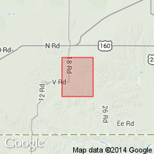
Huckleberry Ridge ash bed (informal). Lenticular silver-gray volcanic ash. Thickness 0 to 1 m. Lies within upper unnamed member of Crooked Creek Formation, beneath Borchers fauna and about 20 m below Lava Creek B ash bed. Previously called Pearlette type B ash bed. Source in Yellowstone National Park. Age is Pliocene. [Pliocene-Pleistocene boundary placed at 1.8 Ma.]
Sanidine crystals from a sample collected within quadrangle yielded a laser-fusion 40Ar/39Ar age of 2.11 +/-0.01 Ma (G.A. Izett, unpub. data, 1990). Sanidine obtained from 8 samples of its source-area equivalent, the Huckleberry Ridge Tuff, was dated by laser-fusion 40Ar/39Ar method at 2.09 +/-0.01 Ma by Obradovich and Izett (GSA Abs. with Prog., v. 23, p. 84, 1991).
Source: Publication.
For more information, please contact Nancy Stamm, Geologic Names Committee Secretary.
Asterisk (*) indicates published by U.S. Geological Survey authors.
"No current usage" (†) implies that a name has been abandoned or has fallen into disuse. Former usage and, if known, replacement name given in parentheses ( ).
Slash (/) indicates name conflicts with nomenclatural guidelines (CSN, 1933; ACSN, 1961, 1970; NACSN, 1983, 2005, 2021). May be explained within brackets ([ ]).