The National Geologic Map Database is migrating to a new infrastructure. We apologize for any service disruptions during this process.
|
|---|


- Usage in publication:
-
- Hosselkus limestone
- Modifications:
-
- First used
- Dominant lithology:
-
- Limestone
- AAPG geologic province:
-
- Sierra Nevada province
- Klamath Mountains province
Summary:
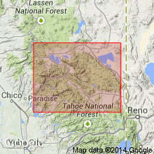
Geologic column of Taylorville [Taylorsville] region shows Hosselkus limestone as 140 ft thick and Late Triassic (early Karnian) age. Is well exposed near Cosmopolitan mine on divide between Genesee Valley and Hosselkus Creek. Contains numerous ARCESTES and abundant pentagonal crinoid stems which indicate Late Triassic age. Has been recognized at numerous outcrops between Spanish Ranch and Prattville and northwestward beyond Pit River in Klamath Mountains. Considered to be younger than Swearinger slates and older than Trail beds.
Source: GNU records (USGS DDS-6; Menlo GNULEX).
- Usage in publication:
-
- Hosselkus Limestone*
- Modifications:
-
- Named
- Biostratigraphic dating
- Dominant lithology:
-
- Limestone
- AAPG geologic province:
-
- Sierra Nevada province
- Klamath Mountains province
Summary:
Named for fact unit forms prominent ledges on divide between Genesee Valley and Hosselkus Creek, 1 mi northeast of Hosselkus ranch, Plumas Co, CA. Is dark-blue to light-gray limestone, thin-bedded, in some places decidedly slaty, fossiliferous. Thickness is 140 ft. Is well developed in Redding region where upper part is lighter colored and more massive and contains spirifer-like shell, and lower part is thinner bedded and darker, with small coiled forms. Conformably overlain (not underlain as originally assumed) by Swearinger slate, and unconformably underlain by Robinson formation. In Redding region is separated from Robinson horizon by 1000 ft of andesitic and rhyolitic lavas which are overlain by 1500 ft of shales, sandstones and tuffs of Triassic age. List of fossils identified by Prof. Alpheus Hyatt indicate Late Triassic age.
Source: GNU records (USGS DDS-6; Menlo GNULEX).
- Usage in publication:
-
- Hosselkus Limestone*
- Modifications:
-
- Areal extent
- AAPG geologic province:
-
- Sierra Nevada province
- Klamath Mountains province
Summary:
(advance copy). Unit geographically extended into report area (Soda Ravine block-Lake Almanor area of northern California). Age is Late Triassic.
Source: GNU records (USGS DDS-6; Menlo GNULEX).
For more information, please contact Nancy Stamm, Geologic Names Committee Secretary.
Asterisk (*) indicates published by U.S. Geological Survey authors.
"No current usage" (†) implies that a name has been abandoned or has fallen into disuse. Former usage and, if known, replacement name given in parentheses ( ).
Slash (/) indicates name conflicts with nomenclatural guidelines (CSN, 1933; ACSN, 1961, 1970; NACSN, 1983, 2005, 2021). May be explained within brackets ([ ]).