

- Usage in publication:
-
- Hoppers Formation*
- Modifications:
-
- Named
- Dominant lithology:
-
- Sandstone
- Claystone
- Siltstone
- AAPG geologic province:
-
- Montana folded belt
Summary:
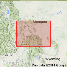
Named as upper formation of Livingston Group (rank raised) for Hoppers Siding on Northern Pacific Railway in SW1/4 sec 7 and NW1/4 sec 18, T2S, R9E (also the type section), Park Co, MT, Montana folded belt province. Conformably overlies Billman Creek Formation (new) of Livingston Group. Is 965 ft thick at type. Consists of ridge-forming, yellow green sandstone (60% of formation) that is massive to thin bedded, cross-bedded, and poorly sorted. Sandstone has angular to subround grains of volcanic rock, plagioclase, augite, hornblende, magnetite, biotite, quartz, and orthoclase cemented by silica or calcite. Many sandstones are channel-fill deposits. Basal sandstone beds are cliff forming, massive, cross-bedded, calcareous and conglomeratic, and are generally banded by layers of ferromagnesian minerals. Claystone makes up about 25% and is olive gray, massive bedded, and contains calcareous claystone concretions, and fresh-water mollusks. Siltstone makes up remainder of formation. Underlies Fort Union Formation of Late Cretaceous (Maestrichtian) and Paleocene age. Assigned a Late Cretaceous, Maestrichtian age. Correlation chart.
Source: GNU records (USGS DDS-6; Denver GNULEX).
- Usage in publication:
-
- Hoppers Formation*
- Modifications:
-
- Overview
- AAPG geologic province:
-
- Montana folded belt
Summary:
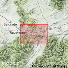
Detailed description of type measured section given. Is a nonmarine unit of Livingston Group lying between Billman Creek Formation of Livingston below and Fort Union Formation. Mapped from T1S, R6E, Gallatin Co east to T1S, R10E, Park Co, Montana folded belt province. Fossils rare. Poorly preserved palynomorphs, freshwater clams and snails identified. Correlates with upper Hell Creek Formation. Assigned to Late Cretaceous, Maestrichtian age. Correlation chart. Geologic map.
Source: GNU records (USGS DDS-6; Denver GNULEX).
For more information, please contact Nancy Stamm, Geologic Names Committee Secretary.
Asterisk (*) indicates published by U.S. Geological Survey authors.
"No current usage" (†) implies that a name has been abandoned or has fallen into disuse. Former usage and, if known, replacement name given in parentheses ( ).
Slash (/) indicates name conflicts with nomenclatural guidelines (CSN, 1933; ACSN, 1961, 1970; NACSN, 1983, 2005, 2021). May be explained within brackets ([ ]).