

- Usage in publication:
-
- High Falls shales
- Modifications:
-
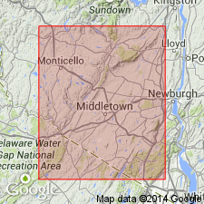
- Named
- Dominant lithology:
-
- Shale
- AAPG geologic province:
-
- Appalachian basin
Summary:
Named the High Falls shales for High Falls, Ulster Co., NY. Consists of red shale that overlies the Shawangunk grit and conglomerate and underlies the Binnewater quartzites. Unit is considered the basal unit of the Salina beds in eastern NY. The High Falls is of Late Silurian age.
Source: GNU records (USGS DDS-6; Reston GNULEX).
- Usage in publication:
-
- High Falls formation
- Modifications:
-
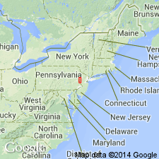
- Areal extent
- AAPG geologic province:
-
- Appalachian basin
Summary:
Geographically extended the High Falls formation to Pennsylvania where it is mapped below the Delaware Water Gap. Unit overlies the Shawangunk formation and underlies the Cayuga group (formation). The High Falls is considered synonymous with the Bloomsburg red beds. It is a predominantly red (with some dull greenish) shaly unit with some sandstone.
Source: GNU records (USGS DDS-6; Reston GNULEX).
- Usage in publication:
-
- High Falls Shale*
- Modifications:
-
- Overview
- AAPG geologic province:
-
- Appalachian basin
Summary:
The High Falls Shale consists of a 55 foot thick lower unit of red and green shale and green dolomite, a 12 foot thick medial unit of green, calcareous dolomite with a bed of dark-gray, laminated dolomite at the base, and a 25 foot thick upper unit of gray, green, and red calcareous and silty shale with some thin dolomite beds. The basal contact of the High Falls is placed at the base of the first red bed above the uppermost quartzite or conglomerate of the Shawangunk Formation and the upper contact is gradational with the overlying Binnewater Sandstone. Unit ranges from 46 to 100 feet thick. The High Falls Shale has been confused by some earlier workers as being equivalent to the Bloomsburg Red Beds.
Source: GNU records (USGS DDS-6; Reston GNULEX).
For more information, please contact Nancy Stamm, Geologic Names Committee Secretary.
Asterisk (*) indicates published by U.S. Geological Survey authors.
"No current usage" (†) implies that a name has been abandoned or has fallen into disuse. Former usage and, if known, replacement name given in parentheses ( ).
Slash (/) indicates name conflicts with nomenclatural guidelines (CSN, 1933; ACSN, 1961, 1970; NACSN, 1983, 2005, 2021). May be explained within brackets ([ ]).