The National Geologic Map Database is migrating to a new infrastructure. We apologize for any service disruptions during this process.
|
|---|


- Usage in publication:
-
- Higginsville limestone member
- Modifications:
-
- Original reference
- AAPG geologic province:
-
- Forest City basin
- Iowa shelf
Summary:
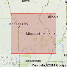
Pg. 26-27 (fig. 2), 36, 63. Higginsville limestone member of Fort Scott formation. Proposed for upper limestone of Fort Scott formation. Traced into Appanoose County, southwestern Iowa. Age is Middle Pennsylvanian (Des Moines).
Well exposed east of Higginsville, Lafayette Co., western MO.
Source: US geologic names lexicon (USGS Bull. 1200, p. 1754-1755).
- Usage in publication:
-
- Higginsville limestone member
- Modifications:
-
- Contact revised
- AAPG geologic province:
-
- Forest City basin
- Cherokee basin
Summary:
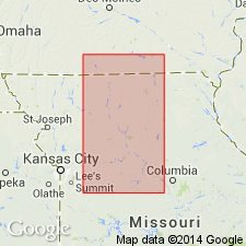
Pg. 308, 309. Higginsville limestone member of Fort Scott limestone of Marmaton group. Overlies Little Osage shale member (new) of Fort Scott. Underlies Labette shale. Average thickness in Kansas about 16 feet. Upper part carries CHAETETES, fusulinids, and a few other fossils. Age is Middle Pennsylvanian (Des Moines).
Beds 11 to 13 in measured section of the type exposure of the Fort Scott limestone, in NE/4 sec. 19, T. 25 S., R. 25 E., Bourbon County, Kansas (pl. 2).
Source: Publication; US geologic names lexicon (USGS Bull. 1200, p. 1754-1755).
- Usage in publication:
-
- Higginsville limestone member
- Modifications:
-
- Contact revised
- AAPG geologic province:
-
- Forest City basin
- Cherokee basin
Summary:
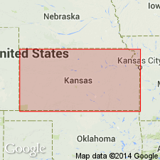
Pg. 6. Higginsville limestone member of Fort Scott formation of Marmaton group. Overlies Flint Hill sandstone bed (new) in Little Osage member of Fort Scott. Age is Middle Pennsylvanian (Des Moines).
Source: US geologic names lexicon (USGS Bull. 1200, p. 1754-1755).
- Usage in publication:
-
- Higginsville limestone member
- Modifications:
-
- Areal extent
- AAPG geologic province:
-
- Chautauqua platform
Summary:
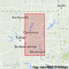
Pg. 14, 16 (fig. 2). Higginsville limestone member of Fort Scott limestone formation. Reaches maximum thickness of 35 feet in Craig County, northeastern Oklahoma, and passes into shale in western Rogers County. Age is Middle Pennsylvanian (Des Moines).
Source: US geologic names lexicon (USGS Bull. 1200, p. 1754-1755).

- Usage in publication:
-
- Higginsville limestone member
- Modifications:
-
- Areal extent
- AAPG geologic province:
-
- Iowa shelf
Summary:
Pg. 33, fig. 5. Higginsville limestone member of Fort Scott limestone of Marmaton group. Medium gray, finely crystalline, and massive. Somewhat more fossiliferous to southeast than in Madison County, southwestern Iowa. Thickness 2 feet in Appanoose County; 1 foot in Madison County. Shale section underlies Higginsville; in Appanoose County, carbonaceous shale is found immediately below the limestone; in Madison County, this shale is reddish brown and contains large ostracodes. Shale interval between Higginsville and overlying Houx Limestone member is about 15 feet in Appanoose and about 7 feet in Madison County. Age is Middle Pennsylvanian (Des Moines).
Source: US geologic names lexicon (USGS Bull. 1200, p. 1754-1755).
- Usage in publication:
-
- Higginsville Limestone Member
- Modifications:
-
- Revised
- AAPG geologic province:
-
- Iowa shelf
Summary:
Extended areally from MO into southern IA on the Iowa shelf. Where it is assigned as the upper member of the newly named Stephens Forest Formation of Marmaton Group of Des Moines Supergroup. Formerly assigned to the Fort Scott Limestone of the Marmaton. Overlies the unnamed shale member of the Stephens Forest. Underlies Labette Shale of the Marmaton. Is of variable character. Ranges from 2 to 10 ft thick. Predominantly calcareous mudstone with several limestones in lower part.
Source: GNU records (USGS DDS-6; Denver GNULEX).
For more information, please contact Nancy Stamm, Geologic Names Committee Secretary.
Asterisk (*) indicates published by U.S. Geological Survey authors.
"No current usage" (†) implies that a name has been abandoned or has fallen into disuse. Former usage and, if known, replacement name given in parentheses ( ).
Slash (/) indicates name conflicts with nomenclatural guidelines (CSN, 1933; ACSN, 1961, 1970; NACSN, 1983, 2005, 2021). May be explained within brackets ([ ]).