

- Usage in publication:
-
- Hermitage formation*
- Modifications:
-
- Original reference
- Dominant lithology:
-
- Limestone
- Shale
- AAPG geologic province:
-
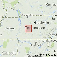
- Appalachian basin
Summary:
Pg. 1. Hermitage formation. Even-bedded, alternating thin layers of argillaceous or siliceous blue limestone and gray or bluish shale in lower third, and heavier-bedded siliceous subangular limestone, more or less strongly phosphatic, in middle and upper parts. Thickness 40 to 70 feet. Unconformably overlies Carters limestone and underlies Bigby limestone. Age is Middle Ordovician (early Trenton).
[Named from occurrence at Hermitage Station, Davidson Co., west-central TN. Extends into southern KY.]
Source: US geologic names lexicon (USGS Bull. 896, p. 945).
- Usage in publication:
-
- Hermitage formation*
- Modifications:
-
- Revised
- AAPG geologic province:
-
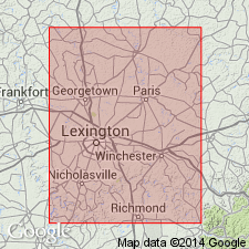
- Cincinnati arch
Summary:
Pg. 41, 42. Hermitage formation included in Lexington group. Overlies Curdsville limestone; underlies Jessamine limestone. Thickness 35 feet near Lexington, southern Kentucky.
Source: US geologic names lexicon (USGS Bull. 1200, p. 1741).
- Usage in publication:
-
- Hermitage formation
- Modifications:
-
- Principal reference
- Revised
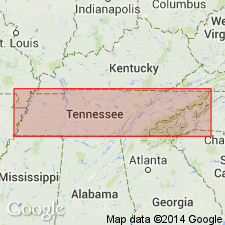
- AAPG geologic province:
-
- Cincinnati arch
Summary:
Pg. 81-107, measured sections. Hermitage formation of Nashville group. Basal formation in Nashville group (redefined). Includes Curdsville member (at base) and facies or members referred to as laminated argillaceous silty nodular limestone; DALMANELLA coquina; granular phosphatic; CTENODONTA; and blue clay-shale. Maximum thickness 180 feet. Underlies Bigby-Cannon formation; unconformably overlies Carters limestone of Stones River group. Hayes and Ulrich referred to section in vicinity of Hermitage Station but did not locate or reproduce the section. Bassler (1932, Tennessee Div. Geol. Bull., no. 38) stated location of section and gave thickness as 67 feet. In present study, several sections were measurede in section in bed of Stoner Creek and northward up hill located just west of bridge on Central Pike over this creek. This is probably locality were section was measured by Ulrich and Bassler.
Type area: near Hermitage Station on hill between Stoner Creek and Lebanon-Nashville and Central Pikes, Davidson Co., west-central TN.
Source: US geologic names lexicon (USGS Bull. 1200, p. 1741).

- Usage in publication:
-
- Hermitage Formation*
- Modifications:
-
- Areal extent
- AAPG geologic province:
-
- Appalachian basin
Summary:
Hermitage Formation of Nashville Group, as defined by Milici and Smith (1969), is here used in Chickamauga terrane in GA.
Source: GNU records (USGS DDS-6; Reston GNULEX).
- Usage in publication:
-
- Hermitage Member
- Modifications:
-
- Revised
- AAPG geologic province:
-
- Appalachian basin
Summary:
Catheys (Catoosa Co.) and Cannon and Hermitage (Walker Co.) regarded as members of Nashville Formation of Chickamauga Group in this report, following the nomenclature of Carter and Chowns (1986: AL Geol. Soc. Guidebook, 23rd Ann. Field Trip) and Carter and Chowns (in press: Amer. Assoc. Pet. Geol., Studies in Geology). Hermitage overlies Carters Member of Stones River Formation in report area.
Source: GNU records (USGS DDS-6; Reston GNULEX).

- Usage in publication:
-
- Hermitage Formation*
- Modifications:
-
- Overview
- AAPG geologic province:
-
- Cincinnati arch
Summary:
The Hermitage Formation of the Nashville Group in central Tennessee is divided into (ascending) the Curdsville Limestone Member, laminated argillaceous member, DALMANELLA coquina member, granular phosphatic member, CTENODONTA member, blue clay-shale member, and silty nodular limestone member. The Curdsville Limestone Member, which onlaps the Carters Limestone on the flanks of the Nashville dome, consists of thin- to medium-bedded, coarsely crystalline limestone. The Hermitage Formation is 70 to 180 feet thick. Overlies the Carters Limestone of the Stones River Group and underlies the Bigby-Cannon Limestone (as used by Wilson, 1949) of the Nashville Group. The Hermitage is of Middle Ordovician (Kirkfieldian) age.
Source: GNU records (USGS DDS-6; Reston GNULEX).
For more information, please contact Nancy Stamm, Geologic Names Committee Secretary.
Asterisk (*) indicates published by U.S. Geological Survey authors.
"No current usage" (†) implies that a name has been abandoned or has fallen into disuse. Former usage and, if known, replacement name given in parentheses ( ).
Slash (/) indicates name conflicts with nomenclatural guidelines (CSN, 1933; ACSN, 1961, 1970; NACSN, 1983, 2005, 2021). May be explained within brackets ([ ]).