The National Geologic Map Database is migrating to a new infrastructure. We apologize for any service disruptions during this process.
|
|---|


- Usage in publication:
-
- Hawley Formation*
- Modifications:
-
- Overview
- AAPG geologic province:
-
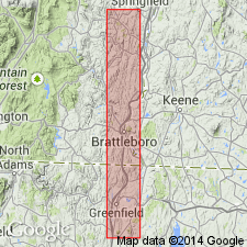
- New England province
Summary:
Used as Hawley Formation of Middle Ordovician age. Mapped undivided as interbedded amphibolite, greenstone, schist, and granofels. Also divided into four informal units: black schist and dark quartzite with interlayered amphibolite; plagioclase gneiss; plagioclase-hornblende-chlorite schist containing megacrysts and angular fragments of granofels and amphibolite; and plagioclase granofels containing garnet and plagioclase-hornblende-garnet gneiss containing hornblende blades and garnet megacrysts.
Source: GNU records (USGS DDS-6; Reston GNULEX).
- Usage in publication:
-
- Hawley Formation*
- Modifications:
-
- Overview
- AAPG geologic province:
-
- New England province
Summary:
Hawley Formation can be divided into five unnamed members, four consisting of metavolcanic rocks and one of black schists containing minor metavolcanic material. Most widespread member consists of green, medium-grained plagioclase-hornblende-epidote-chlorite greenstone and amphibolite and lesser amounts of feldspathic schist and granulite, widespread in northern part of MA. Relict pillows seen locally. Percentage of felsic rocks decreases south of Plainfield, MA. Other members include 1) medium- to coarse-grained plagioclase-quartz gneiss (resembling and in part contemporaneous with felsic gneiss of Collinsville Formation, but the two formations developed in separate stratigraphic belts); 2) medium- to dark-gray plagioclase-hornblende-chlorite schist occurring as two mappable lenses between Charlemont and Plainfield; 3) very light-green to light-buff plagioclase granulite occurring as a lenticular body between Charlemont and Plainfield; and 4) generally rusty-weathering, dark-gray, fine- to medium-grained sulfidic quartz-muscovite-biotite schist containing conspicuous carbonaceous material. Hawley Formation achieves maximum outcrop width (and presumed maximum thickness) near latitude of Charlemont where formation is about 99 percent metabasalt and meta-andesite and about 1 percent black schist. Formation thins north and south of Charlemont as percentage of black schist increases. These relations suggest a volcanic center of basalt in the Middle Ordovician section, similar to Barnard Volcanic Member of Missisquoi Formation in VT. North of Blandford, Hawley intercalates with Cobble Mountain Formation. Age is Middle Ordovician based on tenuous lithic correlation of Hawley black schists with fossiliferous black schists at Magog, Quebec, and in northwestern ME, and a lateral correlation with Ammonoosuc Volcanics (dated as Ordovician by Naylor (1969) and Brookins (1968)) in Bronson Hill anticlinorium to the east. [Papers presented as chapters in U.S. Geological Survey Professional Paper 1366 are intended as explanations and (or) revisions to MA State bedrock geologic map of Zen and others (1983) at scale of 1:250,000.]
Source: GNU records (USGS DDS-6; Reston GNULEX).
- Usage in publication:
-
- Hawley Formation
- Modifications:
-
- Age modified
- Overview
- AAPG geologic province:
-
- New England province
Summary:
As used here the Hawley includes amphibolite, sulfidic rusty schists, abundant coticules, silvery schists, quartzites and quartz conglomerates, and quartz, feldspar, biotite granulites. The quartzites and quartz conglomerates occur at two positions in rocks here assigned to the Hawley. Those occurring near the top have been mapped previously as Russell Mountain Formation or as Shaw Mountain Formation. The Hawley overlies the Ordovician Barnard Gneiss and underlies Silurian and Devonian "calciferous schists" that include the westernmost Goshen Formation in MA and Northfield Formation in southern VT, the central Waits River Formation and the eastern Gile Mountain Formation. Authors believe that the Goshen, Northfield, and Waits River are facies equivalents, while the Gile Mountain is slightly younger. Map symbol indicates that Hawley is Ordovician and Silurian. 40Ar/3Ar hornblende release spectrum date of 433+/-3 Ma obtained by Spear and Harrison (1989).
Source: GNU records (USGS DDS-6; Reston GNULEX).
For more information, please contact Nancy Stamm, Geologic Names Committee Secretary.
Asterisk (*) indicates published by U.S. Geological Survey authors.
"No current usage" (†) implies that a name has been abandoned or has fallen into disuse. Former usage and, if known, replacement name given in parentheses ( ).
Slash (/) indicates name conflicts with nomenclatural guidelines (CSN, 1933; ACSN, 1961, 1970; NACSN, 1983, 2005, 2021). May be explained within brackets ([ ]).