

- Usage in publication:
-
- Hartsell sandstone
- Modifications:
-
- Named
- Dominant lithology:
-
- Sandstone
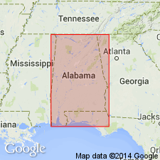
- AAPG geologic province:
-
- Black Warrior basin
Summary:
Mountain limestone (Chester), 200 to 2,000 feet thick, divided into two contemporary units, Bangor or limestone phase, including Hartsell sandstone, and Oxmoor or shale and sandstone phase. In northern Alabama, limestones prevail, with one or more interbedded sandstones, the Hartsell or Lagrange sandstones. To south and southeast of Wills Valley the limestones are replaced by shales and sandstones well exposed at Oxmoor. The Mountain limestone underlies Coal Measures and overlies Fort Payne, which is divided into Tuscumbia limestone above and Lauderdale cherty limestone below. [As thus defined Hartsell sandstone evidently included Hartselle sandstone restricted and the older Cypress sandstone of present [ca. 1938] nomenclature, but apparently did not include Gasper formation and Bethel sandstone.] Age is Mississippian (Chester).
Source: US geologic names lexicon (USGS Bull. 896, p. 919).
- Usage in publication:
-
- Hartselle sandstone*
- Modifications:
-
- Overview
- AAPG geologic province:
-
- Black Warrior basin
Summary:
In northwestern AL, Hartselle overlies Green Hill member of Pride Mountain formation (both new). Underlies Bangor limestone. Thickness about 140 ft in central Colbert Co. Thins eastward to 10 ft at Monte Sano, Madison Co. Consists chiefly of fine-grained sandstone. A few beds of siltstone and shale present at most localities. Asphaltic at many places. Contains marine fossils and plant fossils.
Source: GNU records (USGS DDS-6; Reston GNULEX).
- Usage in publication:
-
- Hartselle Formation
- Modifications:
-
- Overview
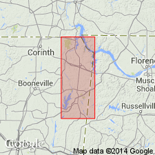
- Areal extent
- AAPG geologic province:
-
- Black Warrior basin
Summary:
Hartselle Formation, rather than Highland Church Member of Forest Grove Formation of Morse (1928), used in this report for the interval overlying the Pride Mountain Formation. The Hartselle consists, for the most part, of a thin- to thick-bedded, well-cemented, sparingly fossiliferous, quartz sandstone sequence. Contains occasional thin intervals of sandy shale, and isolated intervals and zones of calcareous sandstone and shale. Maximum exposed thickness is 30 ft, and massive sandstones often form small cliffs and overhangs. Reaches 64 ft in subsurface of southwestern Tishomingo Co, MS, and 175 ft in the subsurface of Franklin Co., AL. Unit thins northward through TN and south-central KY and is replaced by the Newman Limestone in eastern KY. Westernmost limit of the Hartselle is probably the subsurface of eastern Prentiss Co., MS. Grades into the Floyd Shale in eastern portions of Itawamba Co. Uppermost portion of the Hartselle in northeastern MS is truncated by the erosional surface at the base of the Cretaceous and formation unconformably underlies the Tuscaloosa or Eutaw Groups. Age is Chesterian.
Source: GNU records (USGS DDS-6; Reston GNULEX).
- Usage in publication:
-
- Hartselle Sandstone
- Modifications:
-
- Overview
- AAPG geologic province:
-
- Black Warrior basin
Summary:
Hartselle Sandstone of northwestern and north-central AL occurs in a northwest-southeast trending band, about 80 km wide and 50 m thick. Contacts with both the underlying Pride Mountain Formation and the overlying Bangor Limestone are sharp. Deposition here interpreted as terminal phase of lowstand wedge. Beginning in north-central AL and continuing north into south-central KY, the less than 10-m-thick Hartselle represents deposition in a transgressive systems tract.
Source: GNU records (USGS DDS-6; Reston GNULEX).

- Usage in publication:
-
- Hartselle Sandstone
- Modifications:
-
- Overview
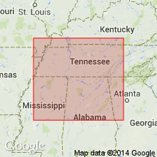
- Areal extent
- AAPG geologic province:
-
- Appalachian basin
Summary:
Unit is widely distributed. It crops out in the Valley and Ridge, Appalachian Plateaus, and Interior Low Plateaus in AL. It occurs from near Attalla in Etowah Co. through St. Clair, Blount, and Jefferson Cos. The Hartselle pinches out along the southeast flank of Red Mountain in Jefferson Co. east of Bessemer. Southeast of Bessemer this 100- to 200-foot thick sandstone forms ridges within the Floyd Shale on the northwest and southeast flanks of Jones Valley. These ridges are almost continuous to the Coastal Plain onlap in Tuscaloosa Co. The Hartselle is the thickest, most widely distributed quartzose lithology of the Mississippian Period in AL. Overlies the Pride Mountain Formation and Monteagle Limestone and underlies the Bangor Limestone and Floyd Shale. It is a thin- to thick-bedded and massive, light-colored fine- to medium-grained quartzose sandstone with interbeds of dark-gray shale. Thickness ranges from 0 to about 150 ft in the Valley and Ridge and Appalachian Plateaus. In the Interior Low Plateaus in Colbert Co., the Hartselle is up to 260 ft thick. Unit is characterized by cross laminations in the thicker bedded sections and ripple marks are locally present. Induration varies throughout its outcrop area. In many places, the Hartselle is very poorly cemented and friable, while in other exposures, the sandstone is hardened with silica and iron oxide cement.
Source: GNU records (USGS DDS-6; Reston GNULEX).
- Usage in publication:
-
- Hartselle Sandstone
- Modifications:
-
- Overview
- AAPG geologic province:
-
- Black Warrior basin
Summary:
Hartselle Sandstone of northern AL contains diverse suite of trace fossils, composed of 23 ichnospecies, described in this report. Sandstone was deposited as a strand-plain complex, later reworked as sea level rose. Lower part consists mainly of thickly bedded beach to shoreface sandstone and is unbioturbated. Upper part consists chiefly of wavy-bedded back-barrier to shelf sandstone with four trace-fossil assemblages representing different paleoenvironments. Ranges in thickness from 0 to 165 ft. Age of the Hartselle is middle Chesterian.
Source: GNU records (USGS DDS-6; Reston GNULEX).
For more information, please contact Nancy Stamm, Geologic Names Committee Secretary.
Asterisk (*) indicates published by U.S. Geological Survey authors.
"No current usage" (†) implies that a name has been abandoned or has fallen into disuse. Former usage and, if known, replacement name given in parentheses ( ).
Slash (/) indicates name conflicts with nomenclatural guidelines (CSN, 1933; ACSN, 1961, 1970; NACSN, 1983, 2005, 2021). May be explained within brackets ([ ]).