


- Usage in publication:
-
- Hartland shale member*
- Modifications:
-
- Original reference
- Dominant lithology:
-
- Shale
- Limestone
- AAPG geologic province:
-
- Anadarko basin
Summary:
Pg. 203. Hartland shale member of Greenhorn limestone. Chalky shale, with a few thin beds of chalky limestone. Thickness 28 to 40 feet. A member of Greenhorn limestone, underlying Jetmore chalk member and overlying Lincoln limestone member. Age is Late Cretaceous.
Named from exposures along Arkansas River, from a short distance west of Hartland, Kearny Co., to Kendall, Hamilton Co., western KS.
Source: US geologic names lexicon (USGS Bull. 896, p. 918).

- Usage in publication:
-
- Hartland shale member*
- Modifications:
-
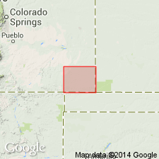
- Areal extent
- AAPG geologic province:
-
- Central Kansas uplift
- Anadarko basin
Summary:
Pg. 25. Hartland shale member of Greenhorn limestone. Chalky shale, a few thin beds of chalky limestone and bentonite. Thickness 23 feet in Kearny County to 35 feet in Ellis County, western Kansas. Underlies Jetmore chalk member; overlies Lincoln limestone member. Age is Late Cretaceous.
Source: US geologic names lexicon (USGS Bull. 1200, p. 1691-1692).
- Usage in publication:
-
- Hartland shale member*
- Modifications:
-
- Areal extent
- AAPG geologic province:
-
- Anadarko basin
Summary:
Pg. 115-116, 117 (fig. 42). Hartland shale member of Greenhorn limestone. In Baca County, southeastern Colorado, consists almost entirely of light-gray chalky shale; locally contains one or more thin beds of dense chalky limestone and a few thin layers of bentonite. Thickness about 30 feet. Underlies Bridge Creek limestone member; overlies Lincoln limestone member. Age is Late Cretaceous.
Source: US geologic names lexicon (USGS Bull. 1200, p. 1691-1692).
- Usage in publication:
-
- Hartland Shale Member*
- Modifications:
-
- Reference
- Dominant lithology:
-
- Shale
- Bentonite
- AAPG geologic province:
-
- Denver basin
Summary:
Pg. 5 (table 1), 17-18. Hartland Shale Member of Greenhorn Limestone. Mostly calcareous shale 59 feet thick which contains thin calcarenite and bentonite beds. Underlies Bridge Creek Limestone Member and overlies Lincoln Limestone Member, both of the Greenhorn. Age is Late Cretaceous (Cenomanian), based on fossils.
Reference section: at Rock Canyon anticline, a few mi west of Pueblo, in SW/4 sec. 30 T. 29 S., R. 65 W., Pueblo Co., southeastern CO.
Source: Publication.
- Usage in publication:
-
- Hartland Member*
- Modifications:
-
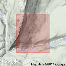
- Areal extent
- AAPG geologic province:
-
- Las Vegas-Raton basin
Summary:
Hartland Member of Greenhorn Formation. Extended into Gold Creek area, in sec. 4, T. 31 N., R. 17 E., Colfax County, New Mexico [The Wall 7.5-min quadrangle]. Consists of calcareous dark gray shale with a few thin bentonite beds. Thickness 52 feet. Overlies Lincoln Member and underlies Bridge Creek Limestone Member, both of Greenhorn. Fossiliferous (a few inoceramid prisms and shell fragments). Age is Late Cretaceous.
Source: Modified from GNU records (USGS DDS-6; Denver GNULEX).
- Usage in publication:
-
- Hartland Shale Member*
- Modifications:
-
- Biostratigraphic dating
- AAPG geologic province:
-
- Denver basin
Summary:
Pg. 3 (table 1), 19-20, 26 (table 2). Hartland Shale Member of Greenhorn Limestone. Ammonite NEOCARDIOCERAS DENSICOSTATUM Cobban, n. sp. collected from shale bed underlying a 15-cm-thick bed of bentonite in the upper part of the Hartland Shale Member, on south side highway at east edge of Eldorado Springs, in SW/4 sec. 30, T. 1 S., R. 70 W., Boulder Co., CO, indicates upper Cenomanian (DUNVEGANOCERAS CONDITUM subzone of METOICOCERAS MOSBYENSE zone).
Source: Publication.
- Usage in publication:
-
- Hartland Member*
- Modifications:
-
- Areal extent
- AAPG geologic province:
-
- Orogrande basin
- San Juan basin
GNU Staff, 1996, Draft copy of Ridgley, J.L., Geologic map of the Rio Chama Wilderness Study Area, Rio Arriba County, New Mexico, USGS Misc. Field Studies Map MF-2046 (unpublished): U.S. Geological Survey Digital Data Series, DDS-6, 1 CD-ROM., release 3
Summary:
Hartland Member of Mancos Shale. Previously mapped as Graneros Shale Member of Mancos by Landis and Dane (1967). Thickness about 100 feet. Underlies Bridge Creek Limestone Member of Mancos. Age is Late Cretaceous.
[See also Ridgeley and others, USGS Bull. 1733-C, 1988.]
Source: Modified from GNU records (USGS DDS-6; Denver GNULEX).
For more information, please contact Nancy Stamm, Geologic Names Committee Secretary.
Asterisk (*) indicates published by U.S. Geological Survey authors.
"No current usage" (†) implies that a name has been abandoned or has fallen into disuse. Former usage and, if known, replacement name given in parentheses ( ).
Slash (/) indicates name conflicts with nomenclatural guidelines (CSN, 1933; ACSN, 1961, 1970; NACSN, 1983, 2005, 2021). May be explained within brackets ([ ]).