

- Usage in publication:
-
- Harrison beds
- Modifications:
-
- Original reference
- Dominant lithology:
-
- Sandstone
- AAPG geologic province:
-
- Chadron arch
- Denver basin
Hatcher, J.B., 1902, Origin of the Oligocene and Miocene deposits of the Great Plains: American Philosophical Society Proceedings, v. 41, p. 113-131.
Summary:
Pg. 117. Harrison beds. Fine-grained rather incoherent sandstones permeated by great numbers of siliceous tubes arranged vertically. Characterized by DAEMONELIX and other Miocene mammals. Well shown in bluffs of all small streams that head near summit of Pine Ridge in vicinity of Harrison, [Sioux County], western Nebraska. Cover considerable area. Extend well into eastern Wyoming. [Age is early Miocene.]
Source: US geologic names lexicon (USGS Bull. 896, p. 915).

- Usage in publication:
-
- Harrison beds†
- Modifications:
-
- Abandoned
- AAPG geologic province:
-
- Chadron arch
- Denver basin
Summary:
†Harrison beds abandoned. Are a part of Arikaree formation and of lower Miocene age, according to H.F. Osborn, 1909 (USGS Bull. 361, p. 65-75), and H.J. and M.C. Cook, 1933 (Nebraska Geol. Survey Paper, no. 5, p. 44).
Source: US geologic names lexicon (USGS Bull. 896, p. 915).
- Usage in publication:
-
- Harrison formation
- Modifications:
-
- Areal extent
- AAPG geologic province:
-
- Chadron arch
Summary:
Pg. 226, 227; 1939, GSA Bull., v. 50, no. 8, p. 1252, 1253-1254. Harrison formation. Thickness 200 feet. Harrison here used as defined by Hatcher [1902]. Overlying Marlsand formation not included in Harrison of Hatcher. Application of name "Upper Harrison" to these beds by Peterson and others in recent years is unfortunate as these beds (Marsland) have no close stratigraphic or faunal relation to true Harrison (in Hatcher sense) and are separated from underlying Harrison by most significant and important structural and erosional unconformity in western Nebraska. [Age is early Miocene.]
Source: US geologic names lexicon (USGS Bull. 1200, p. 1686-1687).
- Usage in publication:
-
- Harrison formation
- Modifications:
-
- [Reinstated]
- Dominant lithology:
-
- Sandstone
- AAPG geologic province:
-
- Chadron arch
Schultz, C.B., 1938, The Miocene of western Nebraska: American Journal of Science, 5th series, v. 35, no. 210, p. 441-444.
Summary:
Pg. 442-442, 444. Harrison formation. Considered uppermost unit in Arikaree group. Overlies Monroe Creek formation; underlies Marsland formation (new). Harrison used here as defined by Hatcher [1902]. Peterson, 1906 (Annals Carnegie Mus., v. 4) applied term "Lower Harrison" to the whole of the already named Harrison beds of Hatcher, and "Upper Harrison" was used for the overlying buff-colored deposits which Hatcher miscalled the Nebraska beds of Scott [GSA Bull., v. 5, p. 594-595, 1894]. This has resulted in much confusion of what constitutes the Harrison. "Upper Harrison" beds here named Marsland formation. [Age is early Miocene.]
Source: US geologic names lexicon (USGS Bull. 1200, p. 1686-1687).
- Usage in publication:
-
- "Upper Harrison"
- Modifications:
-
- [Not used]
- AAPG geologic province:
-
- Denver basin
Cook, H.J., and Gregory, J.T., 1941, Mesogaulus praecursor, a new rodent from the Miocene of Nebraska: Journal of Paleontology, v. 15, no. 5, p. 549-552.
Summary:
Pg. 549-552. Described fauna from "Upper Harrison." States that Marsland as defined by Schultz [1938] includes two separable formations: "Upper Harrison" and higher previously unnamed deposits. Marsland is restricted to deposits at type locality and, as thus restricted, is equivalent to unnamed beds between "Upper Harrison" and the Sheep Creek as shown in columnar section of region by Cook and Cook, 1933 (Nebraska Geol. Survey Paper, no. 5, p. 44). New name is not proposed for "Upper Harrison".
Source: US geologic names lexicon (USGS Bull. 1200, p. 1686-1687).
- Usage in publication:
-
- Harrison sandstone
- Modifications:
-
- Redescribed
- Mapped
- Dominant lithology:
-
- Sandstone
- AAPG geologic province:
-
- Chadron arch
Summary:
Pg. 22-26, pls. 1, 7. Harrison sandstone. Described as a sandstone in Box Butte County, Nebraska, where it is 85 to 130 feet thick. Unconformably overlies Monroe Creek sandstone and underlies Marsland formation. [Age is early Miocene.]
Source: US geologic names lexicon (USGS Bull. 1200, p. 1686-1687).
- Usage in publication:
-
- Harrison member
- Modifications:
-
- Revised
- Mapped
- Dominant lithology:
-
- Sand
- Silt
- AAPG geologic province:
-
- Sioux uplift
Summary:
Harrison member of Arikaree formation. Considered a member of Arikaree formation in Bennett County, south-central South Dakota. Consists of light pink to brown or grayish-buff, poorly consolidated, mostly calcareous very fine sand and silt with discontinuous zones of calcareous concretionary nodules increasing in abundance upward; upper part contains thin zones of white limey sandstone and local lenses of garnetiferous sandstone; local gravel. Thickness up to 150 feet. Overlies Monroe Creek member of Arikaree; contact gradational and difficult to locate precisely. Underlies Pliocene Valentine formation; separated by a deeply eroded post-Miocene disconformity. Age is Miocene.
Source: Publication; US geologic names lexicon (USGS Bull. 1200, p. 1686-1687).
- Usage in publication:
-
- Harrison formation
- Modifications:
-
- Mapped
- AAPG geologic province:
-
- Chadron arch
Summary:
Harrison formation of Arikaree group. Maximum thickness estimated to be 60 to 80 feet. Overlies Monroe Creek formation. On regional scale, the Harrison and Monroe Creek become less distinct as separable units eastward from source area; believed that there is little practical value in attempting to map the separately eastward from Patricia and Martin quadrangles. Underlies Valentine formation of Ogallala group. [Age is early Miocene.]
Source: US geologic names lexicon (USGS Bull. 1200, p. 1686-1687).
- Usage in publication:
-
- Harrison formation
- Modifications:
-
- Mapped
- Dominant lithology:
-
- Sand
- AAPG geologic province:
-
- Chadron arch
Summary:
Harrison formation of Arikaree group. In the Sharps Corner quadrangle, Shannon County, southwestern South Dakota, consists of up to 125 feet of massive gray, partly cross-bedded, poorly consolidated fine to very fine sands. Includes "Rosebud" facies. Overlies Monroe Creek formation. [Age is early Miocene.]
[Revised edition (1965), the Miocene Rosebud formation, reddish-buff to brown interbedded sands, silts, and clays, up to 250 feet thick, overlies the Harrison, which is stated to be up to 160 feet thick.]
Source: US geologic names lexicon (USGS Bull. 1200, p. 1686-1687).
- Usage in publication:
-
- Harrison Formation
- Modifications:
-
- Areal extent
- AAPG geologic province:
-
- Chadron arch
- Denver basin
Summary:
Harrison Formation of Arikaree Group. Fine to very fine, gray to light-brownish-gray silty sands with numerous massive "pipy" concretionary layers. Heavy minerals indicate that Harrison sediments were derived from mixed sources and from reworked sediments originally deposited west of study area. No significant heavy mineral zonations of Harrison are evident. Thickness at type locality 280 feet. Is uppermost formation of the Arikaree. Unconformably underlies Marsland Formation of Hemingford Group; locally, contact is placed at top of highly siliceous "Agate bed". Overlies Monroe Creek Formation of Arikaree. Fossils. DAEMONELIX ("Devil's Corkscrews"), generally characteristic of upper 150 feet of formation, occur within 19 feet of base at type locality. Age is Miocene. (Author states stratigraphic nomenclature used in this report is that of the Nebraska Geol. Survey, Univ. Nebraska State Mus., and Univ. Nebraska Dept. Geol., and not necessarily that of the USGS.)
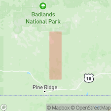
Study area in Sioux, Dawes, and Scotts Bluff Cos., northwestern corner of the Nebraska panhandle. [Type locality shown on fig. 1 to be north of town of Harrison, in center T. 32 N., R. 56 W., Crawford 30- x 60-min quadrangle, Sioux Co., western NE.]
Source: Publication.
- Usage in publication:
-
- Lower Harrison Formation
- Modifications:
-
- Geochronologic dating
- Biostratigraphic dating
- AAPG geologic province:
-
- Denver basin
Summary:
Pg. 178. Lower Harrison Formation (Wood and others, 1941, GSA Bull., v. 52, no. 1, p. 21, 24); [Simpson, 1933, Amer. Mus. Nat. Hist. Bull., v. 67, p. 99]. Sample (KA 481) from gray vitric tuff approximately 30 feet below level of Agate Quarry, STENOMYLUS Quarry and SYNDYOCERAS Quarry on Cook Ranch, Sioux County, Nebraska (H.J. Cook, collector). K-Ar age of 21.3 Ma (biotite); late Arikareean NALMA.
[tuff = informal Agate ash of Skinner and others (1977); occurs 85 feet below top of their Harrison Formation. See also entry under Skinner and others (1977).]
Source: Publication.
- Usage in publication:
-
- Harrison Formation
- Modifications:
-
- Areal extent
- AAPG geologic province:
-
- Chadron arch
- Denver basin
Summary:
Pg. 290-292. Harrison Formation of Arikaree Group. Gray consolidated massive beds of silt and fine "pepper and salt" sand; secondary features DAEMONELIX and "Agate Lime" locally cap the formation. Thickness 200 to 300 feet; may be 500+ feet in places. Unconformably underlies Marsland, Sheep Creek, or Olcott Formations of Hemingford Group, or Snake Creek Formation of Ogallala Group. Includes the informal Agate ash (new), a white, friable, compact ash, 7 to 8 feet thick, lying about 85 feet below top of Harrison and 30 feet below Agate Springs quarries at its type outcrop. Age of Harrison is early Miocene; sample from Agate ash yielded a K-Ar age of 21.3 Ma (= sample KA 481, Evernden and others, 1964, Amer. Jour. Sci., v. 262, p. 164, table 6); Agate Springs fauna is late Arikareean NALMA.
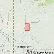
Sample KA 481 (Evernden and others, 1964, p. 178), from type outcrop of Agate ash, located on north side of Niobrara River, 45 ft above water level at 4465 ft elev., [on Cook Ranch] about 2 mi east of former Agate PO, in SE/4 SW/4 sec. 4, T. 28 N., R. 55 W., Sioux Co., Agate Fossil Beds Natl. Mon., northwestern NE.
Source: Publication.
For more information, please contact Nancy Stamm, Geologic Names Committee Secretary.
Asterisk (*) indicates published by U.S. Geological Survey authors.
"No current usage" (†) implies that a name has been abandoned or has fallen into disuse. Former usage and, if known, replacement name given in parentheses ( ).
Slash (/) indicates name conflicts with nomenclatural guidelines (CSN, 1933; ACSN, 1961, 1970; NACSN, 1983, 2005, 2021). May be explained within brackets ([ ]).