

- Usage in publication:
-
- Hannan limestone*
- Modifications:
-
- Original reference
- Dominant lithology:
-
- Limestone
- Breccia
- AAPG geologic province:
-
- Sweetgrass arch
Summary:
Pg. 212 (table 1), 228-231; 1941 [abs.], GSA Bull., v. 52, no. 12, pt. 2, p. 1896. Hannan limestone. Name Hannan limestone proposed for all strata which lie between Devonian and Jurassic rocks in Saypo quadrangle, Sawtooth Range, northwestern Montana. Basal limestone-breccia overlain by gray limestone and alternating units of shaly-bedded argillaceous limestone which grades upward into hard tan- and pale-gray crystalline fossiliferous limestone. Contains much pale-gray chert in nodules and beds as much as 7 inches thick. Upper 200 feet consists of white-gray finely crystalline thin- and thick-bedded dolomite. Thickness 1,370 feet. Disconformably underlies Ellis formation. [Age is Mississippian (Kinderhook to Meramec).]
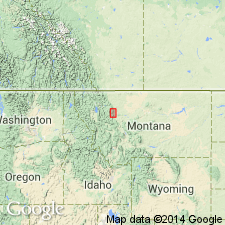
Named from Hannan Gulch where Mississippian rocks form crest of both sides of gulch [Teton Co.]. Almost the complete section of the Hannan is exposed on north side of Sun River Canyon at south end of Castle Reef, which forms east side of Hannan Gulch, [in T. 22 N., R. 9 W., Sawtooth Ridge 7.5-min quadrangle, Teton Co., northwestern MT].
Source: US geologic names lexicon (USGS Bull. 1200, p. 1663-1664).
- Usage in publication:
-
- Hannan limestone
- Modifications:
-
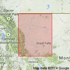
- Areal extent
- AAPG geologic province:
-
- Montana folded belt
- Sweetgrass arch
Summary:
Pg. 1294, 1296. Hannan limestone. In Swift Reservoir and Sun River sections, unconformably underlies Sawtooth formation (new) [of Ellis group]. [Age is Mississippian.]
[Swift Reservoir section in T. 28 N., T. 10 W., Pondera Co., northwestern MT; Sun River section in sec. 36, T. 22 N., R. 9 W., Lewis and Clark Co., northwestern MT.]
Source: US geologic names lexicon (USGS Bull. 1200, p. 1663-1664); GNU records (USGS DDS-6; Denver GNULEX).
- Usage in publication:
-
- Hannan limestone
- Modifications:
-
- Not used
- AAPG geologic province:
-
- Montana folded belt
- Sweetgrass arch
Summary:
Section 8 (Hannan Gulch, sec. 35, T. 22 N., R. 9 W., Sawtooth Range, northwestern MT). Rocks previously assigned to Hannan limestone by Deiss, are instead divided into lithologic units (descending): (1) unit MA, chiefly dolomite of Meramec age; (2) unit MB, chiefly limestone of Osage age; and (3) unit MC, chiefly limestones interbedded with shales of Kinderhook age.
Source: Publication.
- Usage in publication:
-
- Hannan limestone
- Modifications:
-
- Revised
- AAPG geologic province:
-
- Montana folded belt
- Sweetgrass arch
Summary:
Pl. 2 (column 38). Correlation chart shows Hannan limestone to include (ascending) Saypo limestone, Dean Lake chert, Rooney chert, and Monitor Mountain limestone. Age is Mississippian (Kinderhook, Osage, and Meramec).
Source: US geologic names lexicon (USGS Bull. 1200, p. 1663-1664).
- Usage in publication:
-
- Hannan limestone
- Modifications:
-
- Not used
- AAPG geologic province:
-
- Montana folded belt
Summary:
Pg. 85. Hannan limestone. Assignment of group status to the Madison of northwestern Montana by the USGS precludes any need for term Hannan.
Source: US geologic names lexicon (USGS Bull. 1200, p. 1663-1664).
- Usage in publication:
-
- Hannan Limestone*†
- Modifications:
-
- Abandoned
- AAPG geologic province:
-
- Sweetgrass arch
Summary:
Hannan Limestone, a name previously applied to all Mississippian rocks in the Sawtooth Range (Deiss, 1943), abandoned in favor of Madison Group. In Sun River Canyon area, Sweetgrass arch and Montana folded belt province where Hannan Gulch lies, Madison divided into two new formations. Allan Mountain Limestone, at base, which has three informal members (lower, middle, and upper); and Castle Reef Dolomite (at top), which has a lower member and Sun River Member. Sun River is adopted, but is reduced in rank from formation.
Source: GNU records (USGS DDS-6; Denver GNULEX).
For more information, please contact Nancy Stamm, Geologic Names Committee Secretary.
Asterisk (*) indicates published by U.S. Geological Survey authors.
"No current usage" (†) implies that a name has been abandoned or has fallen into disuse. Former usage and, if known, replacement name given in parentheses ( ).
Slash (/) indicates name conflicts with nomenclatural guidelines (CSN, 1933; ACSN, 1961, 1970; NACSN, 1983, 2005, 2021). May be explained within brackets ([ ]).