The National Geologic Map Database is migrating to a new infrastructure. We apologize for any service disruptions during this process.
|
|---|


- Usage in publication:
-
- Hams Fork Conglomerate Member*
- Modifications:
-
- Original reference
- Dominant lithology:
-
- Conglomerate
- Sandstone
- Mudstone
- AAPG geologic province:
-
- Green River basin
Summary:
Pg. 6-9, 12, 41-43 (measured section). Hams Fork Conglomerate Member of Evanston Formation. Boulder conglomerate interstratified with thick beds of coarse partly conglomeratic brown sandstone and gray mudstone. Thickness 455 feet at type section; is about 1,000 feet thick along east side of Fossil basin. Westward, conformably overlies lower unnamed mudstone member of Evanston Formation. Northward, unconformably overlies Adaville, Hilliard, Frontier, Wells, or Twin Creek Formation, and underlies Wasatch Formation. Mapped as Almy Formation by Veatch (1907). Fossils (vertebrates, leaves, gastropods, pollen and spores). Age is Late Cretaceous.
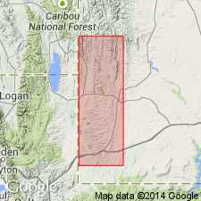
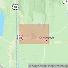
Type section: 1 to 1.5 mi west of strip mine north of Elkol, near middle of eastern part of sec. 36, T. 21 N., R. 117 W., Kemmerer 15-min quadrangle, Lincoln Co., southwestern WY. Named from Hams Fork stream.
Source: Publication; US geologic names lexicon (USGS Bull. 1520, p. 130); Changes in stratigraphic nomenclature, 1970 (USGS Bull. 1354-A, p. A10-A11).
- Usage in publication:
-
- Hams Fork Conglomerate Member*
- Modifications:
-
- Overview
- AAPG geologic province:
-
- Green River basin
Summary:
Is the basal member of the Evanston Formation mapped (geologic map and cross sections) in central east part of area on east side of Fossil basin, Lincoln Co, WY in Greater Green River basin. Has well rounded subspherical clasts from the Worm Creek Quartzite Member of the St. Charles Limestone and from the Brigham Quartzite of ID which weather from brown sandstone matrix. Forms pavements and boulder trains. Underlies Adaville Formation. Overlain by main body of Evanston. May be as much as 1,000 ft thick. Lower part is equivalent to the lower member of the Evanston which occurs only in northeast part of Kemmerer quad. of latest Cretaceous (Lance) age.
Source: GNU records (USGS DDS-6; Denver GNULEX).
- Usage in publication:
-
- Hams Fork Conglomerate Member*
- Modifications:
-
- Biostratigraphic dating
- AAPG geologic province:
-
- Wasatch uplift
- Uinta uplift
- Green River basin
Summary:
Evanston is divisible into a main body (Paleocene, Upper Cretaceous), Hams Fork Conglomerate Member (Upper Cretaceous), and lower member (Upper Cretaceous). Palynological studies indicate a distinct difference in age exists between the main body and the Hams Fork. The main body has yielded palynomorphs that give a middle to late Paleocene age. The Hams Fork has assemblages of late Campanian-Maastrichtian AQUILAPOLLENITES QUADRILOBUS Interval Zone. A 4 to as much as 6 m.y. may separate Hams Fork from the underlying lower member. The AQUILAPOLLENITES SENONICUS Interval Zone is absent in southwest WY and northeast UT thrust belt. This zone represents that missing time. Palynomorphs were collected from the Evanston in Lincoln and Uinta Cos, WY in the Greater Green River basin; in Summit Co, UT on the Uinta uplift; and in Morgan and Rich Cos, UT on the Wasatch uplift.
Source: GNU records (USGS DDS-6; Denver GNULEX).
- Usage in publication:
-
- Hams Fork Member*
- Modifications:
-
- Biostratigraphic dating
- AAPG geologic province:
-
- Uinta uplift
Summary:
Pollen AQUILAPOLLENITES QUADRILOBUS of the late Campanian and early Maestrichtian found 30 m below top of Hams Fork Member of the Evanston Formation in sec 14, T2N, R6E, Summit Co, UT on the Uinta uplift. Same pollen found at 5 other localities. About 800 m thick. Conglomerate in Hams Fork contains clasts of Precambrian quartzite derived from the Willard thrust sheet north of the map area.
Source: GNU records (USGS DDS-6; Denver GNULEX).
For more information, please contact Nancy Stamm, Geologic Names Committee Secretary.
Asterisk (*) indicates published by U.S. Geological Survey authors.
"No current usage" (†) implies that a name has been abandoned or has fallen into disuse. Former usage and, if known, replacement name given in parentheses ( ).
Slash (/) indicates name conflicts with nomenclatural guidelines (CSN, 1933; ACSN, 1961, 1970; NACSN, 1983, 2005, 2021). May be explained within brackets ([ ]).