


- Usage in publication:
-
- Hamlin shale formation
- Modifications:
-
- Original reference
- Dominant lithology:
-
- Shale
- Limestone
- Sandstone
- AAPG geologic province:
-
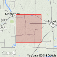
- Forest City basin
Summary:
Pg. 8-9; R.C. Moore, M.K. Elias, and N.D. Newell, 1934, Stratigraphic sections of Pennsylvanian and "Permian" rocks of Kansas River Valley: Kansas Geol. Survey, issued Dec.; R.C. Moore, 1935, Rock formations of Kansas IN Kansas Geol. Soc. [AAPG 20th Ann. Mtg.] March 21-23: Wichita. Hamlin shale formation, 42 to 46 feet thick, is top formation of Admire group. Includes, in section from Forest City, Missouri, to Du Bois, Nebraska (descending) Oaks shale, Houchens Creek limestone, and Stine shale members. Consists of shale, limestone, and sandstone. Overlies Five Point limestone of Admire group; underlies Foraker limestone of Council Grove group. Fossiliferous (pelecypods, brachiopods, bryozoans). Age is considered Permian (lower part of Big Blue).
[Type locality and origin of name not stated.]
Source: US geologic names lexicons (USGS Bull. 896, p. 902; USGS Bull. 1200, p. 1655); GNC KS-NE Pennsylvanian Corr. Chart, sheet 2, Oct. 1936; supplemental information from GNU records (USGS DDS-6; Denver GNULEX).

- Usage in publication:
-
- Hamlin shale
- Modifications:
-
- Overview
- AAPG geologic province:
-
- Forest City basin
Summary:
Pg. 50. Hamlin shale. Adopted this name as defined by Condra, assigned the bed to Permian, but did not state origin of name.
Source: US geologic names lexicon (USGS Bull. 896, p. 902); GNC KS-NE Pennsylvanian Corr. Chart, sheet 2, Oct. 1936.

- Usage in publication:
-
- Hamlin shale member*
- Modifications:
-
- Revised
Summary:
Pg. 2273, 2274 (fig. 1). Hamlin shale member of Janesville shale. Rank reduced to member of Janesville shale (new). Locally contains Houchen Creek limestone bed [also Oaks shale bed and Stine shale bed]. Uppermost member of Janesville; overlies Five Point limestone member. Age is Early Permian (Wolfcampian).
Source: US geologic names lexicon (USGS Bull. 1200, p. 1655).
- Usage in publication:
-
- Hamlin shale member*
- Modifications:
-
- Areal extent
- AAPG geologic province:
-
- Forest City basin
Summary:
Pg. 14 (table 2), 51-52, pl. 2. Hamlin shale member of Janesville shale. Hamlin shale member described in Wabaunsee County, Kansas. Strata now known as Hamlin shale member was included in West Branch shale by Condra (1927) in his reclassification of Admire shale of Adams (1903). Moore, Elias, and Newell (1934) included Stine shale, Houchen Creek limestone, and Oaks shale as members of Hamlin shale. Moore and Mudge (1956) reduced Hamlin to rank of member. Herein suggested that Houchen Creek limestone bed be used as formal name. Recent field work has shown that this bed of Hamlin shale could not be correlated south of Pottawatomie County. Hamlin consists of silty to clayey shales, beds of sandy shale and sandstone, and beds of siltstone, limestone, and conglomerate. Thickness 35 to 45 feet. Overlies Five Point limestone member; underlies Americus limestone member of Foraker limestone. Age is Permian.
Source: US geologic names lexicon (USGS Bull. 1200, p. 1655).
- Usage in publication:
-
- Hamlin Shale Member*
- Modifications:
-
- Areal extent
- AAPG geologic province:
-
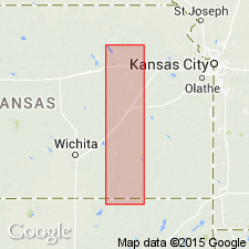
- Chautauqua platform
- Cherokee basin
- Nemaha anticline
Summary:
Hamlin Shale Member of Janesville Shale of Admire Group. Includes (ascending) Stine shale, stromatolitic Houchen Creek limestone, and Oaks shale beds (Pottawatomie County, northeastern Kansas). Overlies Five Point Limestone Member of Janesville and underlies Americus Limestone Member of Foraker Limestone of Council Grove Group. Consists of shale, mudstone (paleosols), and limestone. Locally contains mollusk MYALINA coquina; barren of conodonts. Interpreted to be land and nearshore marine deposits. Age is Late Pennsylvanian (late Gzhelian; STREPTOGNATHODUS FLEXUOSUS conodont zone), based on stratigraphic position.
Described from measured sections in Cowley, Greenwood, and Pottawatomie Counties, eastern Kansas, and Osage County, northern Oklahoma. (Locs. 1, 2, 4, A1, A13, A16, A17, A26.)
Source: Publication.
For more information, please contact Nancy Stamm, Geologic Names Committee Secretary.
Asterisk (*) indicates published by U.S. Geological Survey authors.
"No current usage" (†) implies that a name has been abandoned or has fallen into disuse. Former usage and, if known, replacement name given in parentheses ( ).
Slash (/) indicates name conflicts with nomenclatural guidelines (CSN, 1933; ACSN, 1961, 1970; NACSN, 1983, 2005, 2021). May be explained within brackets ([ ]).