The National Geologic Map Database is migrating to a new infrastructure. We apologize for any service disruptions during this process.
|
|---|


- Usage in publication:
-
- Green Mountain conglomerate
- Modifications:
-
- [Reinstated]
- Revised
- Dominant lithology:
-
- Conglomerate
- AAPG geologic province:
-
- Denver basin
Summary:
Pg. 111-113. Green Mountain conglomerate. Sediments herein designated as Green Mountain conglomerate were assigned to division "D" of Denver formation (Cross, 1896, USGS Mon. 27). Hares (1926) suggested that these conglomerates be removed from Denver formation. Marr (unpub. rept., 1930) gave name Green Mountain conglomerate series to unit. In this report, name Green Mountain conglomerate is retained and unit is removed from Arapahoe-Denver formation. Thickness at least 600 feet. [Age is Eocene.]
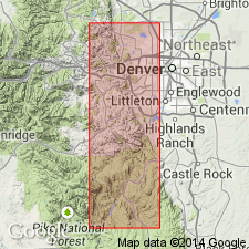
Exposed on slopes of Green Mountain, [situated btw. Lakewood and CO Hwy 470, Morrison 7.5-min quadrangle], Jefferson Co., north-central CO.
Source: US geologic names lexicon (USGS Bull. 1200, p. 1603).
- Usage in publication:
-
- Green Mountain conglomerate
- Modifications:
-
- [Not used]
- AAPG geologic province:
-
- Denver basin
Summary:
Pg. 111. Green Mountain conglomerate should be abandoned because it is a partial representative of Dawson formation as herein restricted. [See also entry under Dawson.]
Source: US geologic names lexicon (USGS Bull. 1200, p. 1603).

- Usage in publication:
-
- Green Mountain Conglomerate*
- Modifications:
-
- Mapped 1:24k (Morrison quad, Jefferson Co, CO)
- Dominant lithology:
-
- Conglomerate
- Sandstone
- Siltstone
- Claystone
- AAPG geologic province:
-
- Denver basin
Summary:
Green Mountain Conglomerate. Restricted to Green Mountain. Consists of conglomerate, sandstone, siltstone, and claystone. Thickness 650 feet. Disconformably overlies Denver Formation; upper contact is an erosional one. Possibly correlates with uppermost part of Dawson Formation in Denver basin. Fossils (leaves, pollen) indicate age is Paleocene.
Named "Green Mountain Conglomerate Series" in an unpublished undergraduate report by J.D. Marr (Colorado School of Mines, Golden, CO, 1929) for Green Mountain, 3 mi northeast of Morrison, Morrison quadrangle, Jefferson Co., north-central CO.
Source: Publication.
For more information, please contact Nancy Stamm, Geologic Names Committee Secretary.
Asterisk (*) indicates published by U.S. Geological Survey authors.
"No current usage" (†) implies that a name has been abandoned or has fallen into disuse. Former usage and, if known, replacement name given in parentheses ( ).
Slash (/) indicates name conflicts with nomenclatural guidelines (CSN, 1933; ACSN, 1961, 1970; NACSN, 1983, 2005, 2021). May be explained within brackets ([ ]).