

- Usage in publication:
-
- Grays Canyon Limestone Member*
- Modifications:
-
- Named
- Dominant lithology:
-
- Limestone
- AAPG geologic province:
-
- Great Basin province
Summary:
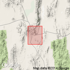
[Presumably named for Grays Canyon; no type section designated by original author] Exposed only in Grays Canyon [39 deg 21'26"N, 115 deg 59'50"W] Pinto Summit 15' quad, Eureka Co, NV. Is 2nd lowest named member of Nevada Formation. Composed of thin-bedded sandy limestone, weathers to shades of tan or light brown. Is locally abundantly fossiliferous with EUREKASPIRIFER PINYONENSIS fauna. Maximum thickness of 300 ft exposed. Overlies Beacon Peak Dolomite Member. Underlies Sentinel Mountain Member. In Grays Canyon represents Oxyoke Canyon Sandstone Member. Is Early and Middle Devonian age.
Source: GNU records (USGS DDS-6; Menlo GNULEX).
- Usage in publication:
-
- Grays Canyon Limestone Member†
- Modifications:
-
- Abandoned
- AAPG geologic province:
-
- Great Basin province
Summary:
"Should never have been named. This is a lateral extension of the McColley Canyon Formation which has priority" (Dick Hose, oral commun., 12/4/77)
Source: GNU records (USGS DDS-6; Menlo GNULEX).
For more information, please contact Nancy Stamm, Geologic Names Committee Secretary.
Asterisk (*) indicates published by U.S. Geological Survey authors.
"No current usage" (†) implies that a name has been abandoned or has fallen into disuse. Former usage and, if known, replacement name given in parentheses ( ).
Slash (/) indicates name conflicts with nomenclatural guidelines (CSN, 1933; ACSN, 1961, 1970; NACSN, 1983, 2005, 2021). May be explained within brackets ([ ]).