

- Usage in publication:
-
- Grayburg formation
- Modifications:
-
- Named
- Dominant lithology:
-
- Dolomite
- Anhydrite
- Sand
- Shale
- AAPG geologic province:
-
- Permian basin
Summary:
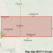
Named as basal of five formations of Whitehorse group (revised--used as a group in this report) in the west TX/ southeast NM area, where a geologic section was compiled from well logs in Eddy and Lea Cos, NM and Andrews, Martin, Dawson, Scurry, and Fisher Cos, TX in Permian basin. The name Grayburg was taken from Grayburg pool which lies 1 mi south of the Root well in SW1/4 SW1/4 sec 7, T17S, R30E, Eddy Co, NM. No type locality designated, but a "sample description" from the Root well shows that the formation characterized primarily by gray, pink, and white dolomite, locally sandy; interbedded with gray and red sands; some anhydrite beds present, and also beds of sandy gray shale and gray and green bentonite. Present between depths of 2,674 ft and 2,380 ft; is 294 ft thick. Can be traced from Eddy Co, NM across the Central Basin platform and the Midland basin and eastward where it becomes primarily clastic and merges with the clastic Whitehorse section on the outcrop in Fisher Co, TX. Conformably underlies Queen formation of Whitehorse; unconformably overlies San Andres formation (formerly used as "Blaine of Texas"). Thickness varies, due to underlying unconformity. Thickness averages close to 300 ft to east in central Borden Co; from there eastward thins considerably. Composition of Grayburg varies considerably throughout southern Permian basin, as do all formations of Whitehorse. Measured section. Permian age.
Source: GNU records (USGS DDS-6; Denver GNULEX).
- Usage in publication:
-
- Grayburg Formation
- Modifications:
-
- Revised
- Reference
- Dominant lithology:
-
- Dolomite
- Sandstone
- Anhydrite
- AAPG geologic province:
-
- Permian basin
Summary:
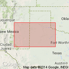
Designated the basal formation of five formations of the shelf sequence assigned to the newly named Artesia Group in Eddy Co, NM in the Permian basin. Overlies San Andres Formation. Underlies Queen Formation of Artesia Group. The lower contact is a dolomite (San Andres)-sandstone (Grayburg) contact. Reference well selected as the Humble Oil and Refining Co. Federal Bogle No. 1 in sec 30, T16S, R30E, Eddy Co where the Grayburg lies between 2,390 and 2,750 ft and is composed of dolomite and thin beds of sandy dolomite, sandstone, and anhydrite. Cross sections. Correlation chart. Geologic map. Of late Guadalupian, Late Permian age.
Source: GNU records (USGS DDS-6; Denver GNULEX).
- Usage in publication:
-
- Grayburg Formation
- Modifications:
-
- Revised
- Overview
- AAPG geologic province:
-
- Orogrande basin
Summary:
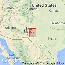
Grayburg Formation, lowermost of five formations of Artesia Group, revised in this report--lower contact changed. The underlying San Andres Formation is here divided into three newly named units (ascending): Rio Bonito, Bonney Canyon, and Fourmile Draw Members. Grayburg rests on Bonney Canyon beds with all of the Fourmile Draw Member missing along the east flank of Sierra Blanca basin extending in a band from the Capitan Mountains southward through Fort Stanton to the Ruidoso area (Lincoln Co, NM in Orogrande basin). Another band of Grayburg occurs north of Capitan Mountains in Ts5 and 6S, Rs13 and 14E, where it overlies Fourmile Draw Member. Absence of Fourmile Draw beds south of the Capitan Mountains, and their presence beneath Grayburg along the western end of the Capitans and northward, suggests post-San Andres uplift south of the Capitan fault and consequent removal of high San Andres beds before Grayburg time (such movement on the Capitan fault is the opposite to that indicated by the present displacement). Or, perhaps there was a low positive area in Fourmile Draw time, during which no deposition occurred. Is Permian (Guadalupian) in age. Geologic map, stratigraphic chart.
Source: GNU records (USGS DDS-6; Denver GNULEX).
For more information, please contact Nancy Stamm, Geologic Names Committee Secretary.
Asterisk (*) indicates published by U.S. Geological Survey authors.
"No current usage" (†) implies that a name has been abandoned or has fallen into disuse. Former usage and, if known, replacement name given in parentheses ( ).
Slash (/) indicates name conflicts with nomenclatural guidelines (CSN, 1933; ACSN, 1961, 1970; NACSN, 1983, 2005, 2021). May be explained within brackets ([ ]).