

- Usage in publication:
-
- Gottsche Tongue
- Modifications:
-
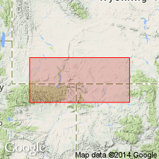
- Areal extent
- AAPG geologic province:
-
- Green River basin
Summary:
Pg. 10, 11. Gottsche Tongue of Rocks Springs Formation of Mesaverde Group. Thin sequence of paludal rocks. Is uppermost tongue of Rock Springs Formation in Rock Springs uplift area, southwestern Wyoming. Underlies Ericson Formation. Overlies McCourt Tongue of the Rock Springs Formation. Age is Late Cretaceous.
Source: US geologic names lexicon (USGS Bull. 1350, p. 300); supplemental information from GNU records (USGS DDS-6; Denver GNULEX).
- Usage in publication:
-
- Gottsche Member
- Modifications:
-
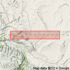
- Principal reference
- AAPG geologic province:
-
- Green River basin
Summary:
Pg. 17, pl. 4. Gottsche Member of Rock Springs Formation. Consists of carbonaceous shales, thin coals, and some lenticular sandstones and gray shale. Thickness 20 to 70 feet. Overlies McCourt Tongue. Age is Late Cretaceous (Claggett).
[Type locality:] on Gottsche Ranch, in sec. 30, T. 16 N., R. 102 W., Sweetwater Co., southwestern WY, where Highway 430 crosses Rock Springs-Ericson contact.
Source: US geologic names lexicon (USGS Bull. 1350, p. 300); GNC index card files (USGS-Reston).
For more information, please contact Nancy Stamm, Geologic Names Committee Secretary.
Asterisk (*) indicates published by U.S. Geological Survey authors.
"No current usage" (†) implies that a name has been abandoned or has fallen into disuse. Former usage and, if known, replacement name given in parentheses ( ).
Slash (/) indicates name conflicts with nomenclatural guidelines (CSN, 1933; ACSN, 1961, 1970; NACSN, 1983, 2005, 2021). May be explained within brackets ([ ]).