

- Usage in publication:
-
- Gilboa beds
- Modifications:
-
- Named
- Dominant lithology:
-
- Sandstone
- Siltstone
- Shale
- AAPG geologic province:
-
- Appalachian basin
Summary:
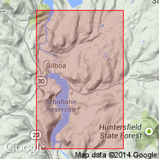
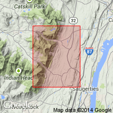
Gilboa beds named in Schoharie Valley, eastern NY, in hills north of Gilboa and southward along shores of Gilboa Reservoir, where SPIRIFER MESASTRIALIS and other Ithaca fossils are common in the sandstones. This division, about 250 ft thick, is equivalent to Tully (Laurens) and Sherburne sandstone, and is Ithaca facies of Sherburne, Geneseo, and Tully. Nearly complete section is exposed in western face of Reed Hill, which is designated as the type section. Age is Late Devonian.
Source: GNU records (USGS DDS-6; Reston GNULEX).
- Usage in publication:
-
- Gilboa formation
- Modifications:
-
- Revised
- AAPG geologic province:
-
- Appalachian basin
Summary:
At the time Gilboa beds were defined, it was believed that all beds between the top of the Hamilton and the "SPIRIFER" MESASTRIALIS zone at Jefferson, Ruth, and elsewhere, 250 ft thick, represented Tully, Geneseo, and Sherburne formations in Schoharie Valley, where they could not be separated. However, it has since been determined that the "SP." MESASTRIALIS zone is not at the base of the Ithaca. Therefore, the Gilboa formation is expanded to include all rocks (325 ft thick) in Schoharie Valley between the top of Hamilton and the base of the red beds of Sherburne age. As thus defined the Gilboa includes Tully and Unadilla formations, which are not here separable because of disappearance of Tully fossil HYPOTHYRIDINA. At place originally designated as type locality, the upper part of formation is absent, but is well exposed along Hwy 30, about 2.5 mi northeast of Grand Gorge. Top of Hamilton in Schoharie Valley is drawn at top of zone containing peculiar plicated terebratuloids, here named RHIPIDOTHYRIS. Best section of the Gilboa is at Intake Building and along road from this building, which connects with road to Hardenburg Falls and Grand Gorge, where base of Gilboa exposed is 10 to 20 ft above top of Hamilton. Although Gilboa fauna is almost wholly composed of Ithaca species, the formation is actually of pre-Ithaca age. East of Schoharie Valley it is represented by Onteora beds of Chadwick. Gilboa as redefined is equivalent to Tully and may include some or all of Geneseo. Age is Late Devonian.
Source: GNU records (USGS DDS-6; Reston GNULEX).
- Usage in publication:
-
- Gilboa formation*
- Modifications:
-
- Overview
- AAPG geologic province:
-
- Appalachian basin
Summary:
Gilboa is described in this report as gray medium- to fine-grained sandstone, thin-bedded siltstone, and dark-gray shale in Schoharie Co.
Source: GNU records (USGS DDS-6; Reston GNULEX).
- Usage in publication:
-
- Gilboa Formation
- Modifications:
-
- Revised
- AAPG geologic province:
-
- Appalachian basin
Summary:
Gilboa Formation subdivided into (ascending) Potter Hollow Member, Manorkill Member, and Grand Gorge Member. Overlies Plattekill Formation and underlies Oneonta Formation. Age is Middle and Late Devonian.
Source: GNU records (USGS DDS-6; Reston GNULEX).
- Usage in publication:
-
- Gilboa Formation
- Modifications:
-
- Revised
- AAPG geologic province:
-
- Appalachian basin
Summary:
Gilboa Formation includes only Grand Gorge as easterly extending tongue. Potter Hollow and Manorkill now considered formations.
Source: GNU records (USGS DDS-6; Reston GNULEX).
- Usage in publication:
-
- Gilboa Formation
- Modifications:
-
- Revised
- AAPG geologic province:
-
- Appalachian basin
Summary:
Assigned to Genesee Group on NY State map. Age is Middle and Late Devonian.
Source: GNU records (USGS DDS-6; Reston GNULEX).
- Usage in publication:
-
- Gilboa Formation
- Modifications:
-
- Overview
- AAPG geologic province:
-
- Appalachian basin
Summary:
Gilboa Formation is described at Stevens Mountain Quarry, Grand Gorge, and Hardenburgh Falls. Formation is composed of 2- to 6-m-thick sandstone bodies separated by thinner mudstone-dominated intervals. Unit is divided into four 15- to 20-m-thick sections by three thick mudstones. The fine- to medium-grained sandstone bodies have sharp, erosional bases with tool and flute marks, overlain by intraformational breccia composed of shale clasts, plant fragments, and shelly fossils. Trough cross-strata are most common, but planar cross-strata occur near the tops of the sandstone bodies. The mudstones are dark gray, sparsely fossiliferous, and typically bioturbated. Variations in facies throughout the Gilboa suggest increasing marine influence through the lowest 20 m and decreasing influence through the upper 30 m. Overlies Moscow Formation. Gradationally underlies Oneonta Formation in study area. Grades eastward into Manorkill Formation. Age in this report is Middle Devonian only.
Source: GNU records (USGS DDS-6; Reston GNULEX).
For more information, please contact Nancy Stamm, Geologic Names Committee Secretary.
Asterisk (*) indicates published by U.S. Geological Survey authors.
"No current usage" (†) implies that a name has been abandoned or has fallen into disuse. Former usage and, if known, replacement name given in parentheses ( ).
Slash (/) indicates name conflicts with nomenclatural guidelines (CSN, 1933; ACSN, 1961, 1970; NACSN, 1983, 2005, 2021). May be explained within brackets ([ ]).