

- Usage in publication:
-
- Gambier Bay Formation*
- Modifications:
-
- Named
- Dominant lithology:
-
- Schist
- Phyllite
- Marble
- AAPG geologic province:
-
- Alaska Southeastern region
Summary:
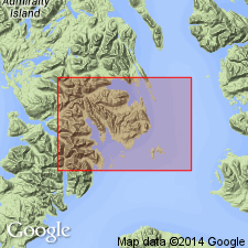
Named for exposures along shores of Gambier Bay. Type locality is designated as exposures along shores of western Gambier Bay from Snug Cove on south to vicinity of triangulation station "Butt" on north, Admiralty Island, southeastern AK. Identified by metamorphic foliation of its rocks which are fine-grained green schist and phyllite. Chief rock types are chlorite-epidote-calcite phyllite or schist, quartz-albite, phyllite, marble, and phyllitic slate. Is few 1000 ft thick. Unconformably underlies Cannery Formation (new). Coeval with Hood Bay Formation (new). Unit as shown on geologic map of Pybus-Gambier area may contain minor amounts of rocks of Permian age. Resembles in general way Wales Group of southeastern AK. Poorly preserved fossils are indicative of Devonian age (probably Middle(?) Devonian) (W.A. Oliver, J. Berdan, and Helen Duncan, written commun., 1959, 1960).
Source: GNU records (USGS DDS-6; Menlo GNULEX).
- Usage in publication:
-
- Gambier Bay Formation*
- Modifications:
-
- Areal extent
- AAPG geologic province:
-
- Alaska Southeastern region
Summary:
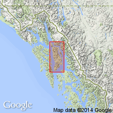
Shown on geologic map of Admiralty Island, southeastern AK. Reconnaissance geology of Admiralty Island from Pybus Bay northwestward to Point Retreat shows schist and marble form backbone and western side of island. Belt of outcrop is not continuous but is interrupted by batholith at Thayer Lake which divides belt into northern and southern segments. Rocks of northern segment are assigned to Retreat Group. In southern segment rocks are continuous with those of Gambier Bay Formation mapped by Loney (1964). Age given as Middle(?) Devonian based on fossils (Edwin Kirk, unpublished data).
Source: GNU records (USGS DDS-6; Menlo GNULEX).
- Usage in publication:
-
- Gambier Bay Formation*
- Modifications:
-
- Areal extent
- AAPG geologic province:
-
- Alaska Southeastern region
Summary:
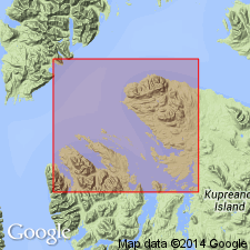
Shown on geologic map of Keku Islets and neighboring parts of Kuiu and Kupreanof Islands, southeastern AK. Marble and amphibolite lithologies shown separately. Is composed primarily of greenstone, greenschist, and pelitic and quartzo-feldspathic phyllite. Marble and recrystallized dolomite form sporadic layers up to 50 ft thick throughout unit. Relation to other stratigraphic units uncertain. Contact with Cannery Formation west of Pinta Point appears to be a fault. Contact to east with Seymour Canal Formation is obscured along shore by alluvium and may be either fault or unconformity. Poorly preserved corals or stromatoporoids from marble of study area identified by C.W. Merriam (oral commun., 1963) as AMPHIPORA or CLADOPORA are possibly Late Silurian or Middle Devonian age. Age given as Middle(?) Devonian.
Source: GNU records (USGS DDS-6; Menlo GNULEX).
For more information, please contact Nancy Stamm, Geologic Names Committee Secretary.
Asterisk (*) indicates published by U.S. Geological Survey authors.
"No current usage" (†) implies that a name has been abandoned or has fallen into disuse. Former usage and, if known, replacement name given in parentheses ( ).
Slash (/) indicates name conflicts with nomenclatural guidelines (CSN, 1933; ACSN, 1961, 1970; NACSN, 1983, 2005, 2021). May be explained within brackets ([ ]).