

- Usage in publication:
-
- Franson member*
- Franson tongue*
- Modifications:
-
- Original reference
- Dominant lithology:
-
- Dolomite
- Limestone
- Sandstone
- AAPG geologic province:
-
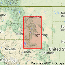
- Uinta uplift
Summary:
[Credited to T.M. Cheney, p. 15-19, 31, 37, pls. 2, 3; T.M. Cheney IN V.E. McKelvey and others, 1956, AAPG Bull., v. 40, no. 12, p. 2842-2843.] Franson member of Park City formation; Franson tongue of Park City formation. Proposed for light-gray and grayish-brown carbonate rock, cherty or sandy carbonate rock, and calcareous sandstone that overlie Meade Peak tongue (new) of Phosphoria formation and underlie Woodside formation. In Montana, Wyoming, and Idaho, has been considered upper part of Rex chert member or the C member of Phosphoria formation (Klepper, 1951, USGS Bull. 969-C). At type locality, about 235 feet thick and consists of a lower unit, about 65 feet thick, of dominantly light-gray and grayish-brown carbonate rock; middle unit, about 85 feet thick, dominantly light-gray and brownish-gray carbonatic sandstone containing chert as beds and nodules; and upper unit, about 85 feet thick, dominantly white and light-gray carbonate rock; some beds of the upper unit, are reddish brown and are probably laterally continuous with Mackentire tongue of Woodside formation. Lower contact gradational but placed at top of gray and greenish-gray cherty phosphatic carbonate rock of upper part of Meade Peak tongue. Thickness 830 feet in southern Wasatch Mountains, but over most of its extent ranges from 50 to 200 feet in thickness. In most of Utah, western Wyoming, and parts of Montana, underlain by tongue of Phosphoria, either Meade Peak or Rex; in eastern Utah and northwestern Colorado, underlain by Weber sandstone; in parts of Montana and Wyoming where Meade Peak and Rex are absent, Franson is difficult to separate from lower (unnamed) member of Park City; in northernmost Utah, eastern Idaho, western Wyoming, and southwestern Montana, interfingers basinward with the Rex, Tosi, and Meade Peak members of Phosphoria, and in Utah intertongues shoreward with red and greenish gray shales of Woodside formation; in western Wyoming, Montana, and northeastern Idaho, Franson tongue is overlain by Retort phosphatic shale member (new) of Phosphoria. Age is Permian.
Named from exposures on north side of Franson Canyon near the mouth, in S/2 SE/4 sec. 15, and N/2 NE/4 sec. 22, T. 1 S., R. 6 E., Summit Co., eastern UT.
Source: US geologic names lexicon (USGS Bull. 1200, p. 1421-1422).
- Usage in publication:
-
- Franson Member*
- Modifications:
-
- Revised
- AAPG geologic province:
-
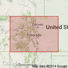
- Uinta basin
- Green River basin
Summary:
Triassic Moenkopi Formation-Permian Park City Formation contact modified on south flank of the Uinta Mountains from Ashley Creek, Uintah Co, UT in the Uinta basin east to Red Rock Canyon, Moffat Co, CO in the Greater Green River basin. A 25 to 67 ft thick unit called the tawny beds, formerly mapped as part of the Moenkopi, is removed from the Moenkopi and reassigned to the upper unit of the Franson Member of the Park City Formation. The tawny beds consist of gray silty limestone and dolomite. A very fine grained, hard, ledge-forming dolomite or limestone marker bed 4 ft thick is distinguishable 10 to 30 ft below the top of the tawny beds. The marker bed contains phosphatic bioclastic debris, abundant fine to very coarse phosphorite pellets, glauconite, silt, sand, and sparse chert beds less than 1 ft thick, and can be traced from Ashley Creek to Red Rocks Canyon. A fossiliferous 0.5 to 3.5 ft thick limestone 5 to 10 ft below the top of the marker bed yielded Permian fossils (bryozoans, brachiopods, ammonoids, gastropods, etc, listed). Tawny beds overlie lower part of upper unit of Franson and underlie red-brown and yellow-gray calcareous siltstone that is ripple marked and has gypsum stringers of the Moenkopi.
Source: GNU records (USGS DDS-6; Denver GNULEX).
- Usage in publication:
-
- Franson Member*
- Modifications:
-
- Biostratigraphic dating
- AAPG geologic province:
-
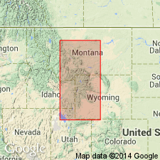
- Wasatch uplift
- Wind River basin
Summary:
Presence of THAMNOSIA, YAKOLEVIA, and KUVELOUSIA Zone fossils (brachiopods) in the Franson Member of the Park City Formation give a Wordian, early Guadalupian, or Early Permian age to the member at Fall Creek, Trail Creek and Montpelier Canyon, ID, and Dry Bread Hollow, north UT on the Wasatch uplift, and at Bull Lake, Fremont Co, WY in the Wind River basin.
Source: GNU records (USGS DDS-6; Denver GNULEX).
- Usage in publication:
-
- Franson Member*
- Modifications:
-
- Overview
- AAPG geologic province:
-
- Uinta uplift
- Uinta basin
- Green River basin
Summary:
Franson Member of Park City Formation of northeast UT, Uinta uplift and Uinta basin, and of adjoining northwest CO, Greater Green River basin, shown on a correlation chart as correlative of 1) Alibates Dolomite Lentil of the Quartermaster Formation of northeast NM, 2) the South Canyon Creek Dolomite Member of the State Bridge Formation of central CO, 3) the Forelle Limestone of north-central CO and south-central WY, 4) the Day Creek Dolomite of eastern CO and western KS. These units are of early Guadalupian, Wordian, Early Permian age.
Source: GNU records (USGS DDS-6; Denver GNULEX).
For more information, please contact Nancy Stamm, Geologic Names Committee Secretary.
Asterisk (*) indicates published by U.S. Geological Survey authors.
"No current usage" (†) implies that a name has been abandoned or has fallen into disuse. Former usage and, if known, replacement name given in parentheses ( ).
Slash (/) indicates name conflicts with nomenclatural guidelines (CSN, 1933; ACSN, 1961, 1970; NACSN, 1983, 2005, 2021). May be explained within brackets ([ ]).