The National Geologic Map Database is migrating to a new infrastructure. We apologize for any service disruptions during this process.
|
|---|


- Usage in publication:
-
- Fowkes formation*
- Modifications:
-
- Original reference
- Dominant lithology:
-
- Limestone
- Ash
- AAPG geologic province:
-
- Green River basin
Summary:
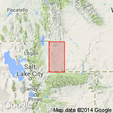
Fowkes formation of Wasatch group. "White beds"; light-colored rhyolitic ash beds with interbedded limestones containing fresh-water shells, fish, and plants. Thickness 0 to 2,500+ feet. Middle formation of Wasatch group in southwestern Wyoming. Unconformably underlies Knight formation and overlies Almy formation (basal Wasatch group). Age is Eocene.
Named from Fowkes Ranch, around which the formation is well exposed; located about 9 mi from Evanston, [near UT-WY State line, in SE/4 sec. 32, T. 17 N., R. 120 W., Neponset Reservoir NE 7.5-min quadrangle, Uinta Co., southwestern WY].
[Additional locality information from USGS historical topographic map collection TopoView, accessed Leap Year Day February 29, 2016.]
Source: US geologic names lexicon (USGS Bull. 896, p. 765-766).
- Usage in publication:
-
- Fowkes formation
- Modifications:
-
- Age modified
- AAPG geologic province:
-
- Green River basin
Summary:
Pg. 20, pl. 1. Fowkes formation. Tentatively assigned to late Paleocene (Tiffanian and Clarkforkian).
Source: US geologic names lexicon (USGS Bull. 1200, p. 1408-1409).
- Usage in publication:
-
- Fowkes formation*
- Modifications:
-
- Areal extent
- AAPG geologic province:
-
- Central Western Overthrust
Eardley, A.J., 1959, Review of geology of northeastern Utah and southwestern Wyoming: Intermountain Association of Petroleum Geologists, Guidebook for the Annual Field Conference, no. 10, p. 166-171.
Summary:
p. 167. Fowkes formation was presumed by Veatch to lie between Almy and Knight formations. He pointed out hills on west side of Bear River valley northwest of Evanston as locality where this relation could best be seen and recognized that in other places the Fowkes is absent. Norwood tuff of early Oligocene age (Eardley, 1944) had been traced from area east of Coalville anticline nearly to Evanston, Wyoming, into tuffaceous outcrops labeled Fowkes by Veatch. Reexamination of geologic map of Evanston area showed Fowkes outcrops to be compatible with a post-Knight age, except those on west side of Bear River. This area was revisited, and the conclusion was reached that the contact is due to normal faulting. These relations are deceptive because a red unit exists in tuffs adjacent to fault, a gray unit exists on other side of fault in the red Knight, and it appears from most ground positions that the Fowkes extends under the Knight. Concluded that the Fowkes is Norwood and of early Oligocene age. Name Fowkes has priority and is applied to all Norwood outcrops.
Source: US geologic names lexicon (USGS Bull. 1200, p. 1408-1409).
- Usage in publication:
-
- Fowkes formation*
- Modifications:
-
- Revised
- Age modified
- AAPG geologic province:
-
- Central Western Overthrust
Summary:
Pg. 128 (table 1), 129, 130. Fowkes formation, as defined by Veatch, and its lithologic equivalents to the north in Fossil Basin are of late Eocene age and are youngest of early Tertiary rocks yet found in basin. Formation appears to be valid formation despite Veatch's misconception regarding its stratigraphic position (between Almy and Knight formations) and its erroneous inclusion in Wasatch group. His lithologies are accurate, and unit is distinctive, recognizable, and mappable. Unit is cut by faults limited in distribution. Formation is here removed from Wasatch group. Separated from underlying Green River formation by unnamed unit consisting of pink and green to red mudstone, sandstone, conglomerate, and interbedded limestone.
Source: US geologic names lexicon (USGS Bull. 1200, p. 1408-1409).
- Usage in publication:
-
- Fowkes Formation*
- Modifications:
-
- Revised
- Age modified
- AAPG geologic province:
-
- Green River basin
Summary:
Pg. 5 (table 1), 33+. Fowkes Formation. Subdivided into (descending; all new): (1) provisionally assigned Gooseberry Member, light-gray to white calcareous and tuffaceous puddingstone, 200+ feet, may be easternmost remnant of Salt Lake Formation; (2) Bulldog Hollow Member, green tuffaceous mudstone and sandstone, 200 to 2,000 feet; and (3) Sillem Member, pale-gray and pinkish-gray mudstone and gray conglomerate, 100 to 400 feet. Fowkes Formation overlies and is younger than both Wasatch and Green River Formations. Fossils (gastropods, ostracodes, leaves). Age of Bulldog Hollow and Sillem Members considered middle to late Eocene (Bridgerian to Duchesnean Provincial Ages of Wood and others, 1941); the provisional Gooseberry Member may be as young as Pliocene.
Source: Publication; Changes in stratigraphic nomenclature, 1970 (USGS Bull. 1354-A, p. A8-A9).
For more information, please contact Nancy Stamm, Geologic Names Committee Secretary.
Asterisk (*) indicates published by U.S. Geological Survey authors.
"No current usage" (†) implies that a name has been abandoned or has fallen into disuse. Former usage and, if known, replacement name given in parentheses ( ).
Slash (/) indicates name conflicts with nomenclatural guidelines (CSN, 1933; ACSN, 1961, 1970; NACSN, 1983, 2005, 2021). May be explained within brackets ([ ]).