

- Usage in publication:
-
- Foraker limestone*
- Modifications:
-
- Original reference
- Dominant lithology:
-
- Limestone
- Shale
- AAPG geologic province:
-
- Chautauqua platform
Summary:
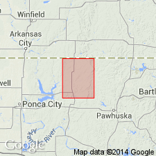
Pg. 21, 25. Foraker limestone. Chiefly limestone, but much of rock is so soft and thin-bedded as to give no outcrop. Some soft shale is present. The heavy limestone can easily be recognized by the large number of FUSULINA which it contains, the rock in places being fairly jammed with them. Another distinguishing mark is great abundance of chert concretions it contains. The fresh surface of the chert is generally light blue gray, and the concretions usually include fossils which show white against the bluish background. Most common fossil in the chert is FUSULINA SECALICA. Thickness 74+/- feet. The limestone forms the rim of Ekler Canyon, and is prominent along line of bluffs in eastern part of Foraker quadrangle, central northern Oklahoma. It lies 18 feet below Red Eagle limestone and is underlain by shale. A sandstone which occurs 28+/- feet below the Foraker is a good horizon marker. Age is Pennsylvanian.
Named from Foraker, Foraker quadrangle, Osage Co., central northern OK.
Source: US geologic names lexicon (USGS Bull. 896, p. 748).
- Usage in publication:
-
- Foraker limestone*
- Modifications:
-
- Revised
- Areal extent
- AAPG geologic province:
-
- Nemaha anticline
Summary:
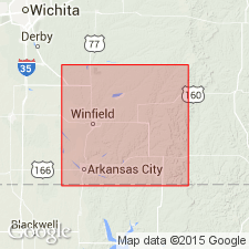
Pg. 45+. Foraker limestone. Thick-bedded limestone containing chert and minor proportion of shale and shaly limestone, with thickness of 50 feet, constitutes Foraker limestone in Cowley County, southern Kansas. Lowermost bed of formation is Americus(?) limestone member. It is separated from upper thick-bedded limestone member by 10 to 13 feet of soft shale. The Foraker overlies Admire shale and underlies Elmdale shale as here restricted. The beds above Americus(?) limestone were formerly included in Elmdale shale. Age is Pennsylvanian.
Source: US geologic names lexicon (USGS Bull. 896, p. 748).
- Usage in publication:
-
- Foraker limestone*
- Modifications:
-
- Revised
- Areal extent
- AAPG geologic province:
-
- Nemaha anticline
- Forest City basin
Summary:
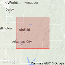
Pg. 45, 50, footnotes. (See under Americus limestone member of Foraker limestone.)
Source: US geologic names lexicon (USGS Bull. 896, p. 748).

- Usage in publication:
-
- Foraker limestone member*
- Foraker limestone*
- Modifications:
-
- Overview
- AAPG geologic province:
-
- Chautauqua platform
- Nemaha anticline
- Forest City basin
Summary:
Foraker limestone. In Oklahoma is top member of Sand Creek formation; in Kansas is treated by the USGS as a formation in Wabaunsee group. Age is Pennsylvanian.
Source: US geologic names lexicon (USGS Bull. 896, p. 748).

- Usage in publication:
-
- Foraker limestone formation
- Modifications:
-
- Areal extent
- AAPG geologic province:
-
- Forest City basin
- Nemaha anticline
Summary:
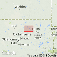
Pg. 8. Foraker limestone formation of Council Grove group. Carried this name into northwestern Missouri and southeastern Nebraska; called it Foraker limestone formation (45 to 50 feet thick); defined it as underlying his Johnson shale formation and overlying his Hamlin shale formation; and divided it into (descending): Long Creek limestone, Hughes Creek shale, and Americus limestone members. Age is considered Permian (lower part of Big Blue).
Source: US geologic names lexicon (USGS Bull. 896, p. 748); GNC KS-NE Pennsylvanian Corr. Chart, sheet 2, Oct. 1936.

- Usage in publication:
-
- Foraker limestone*
- Modifications:
-
- Age modified
- AAPG geologic province:
-
- Forest City basin
- Nemaha anticline
Summary:
Foraker limestone of Council Grove group. Transferred this limestone to Permian (Big Blue series). This change in Permian-Pennsylvanian boundary has not been considered by the USGS for its publications [ca. 1938].
Source: US geologic names lexicon (USGS Bull. 896, p. 748); GNC KS-NE Pennsylvanian Corr. Chart, sheet 2, Oct. 1936.

- Usage in publication:
-
- Foraker limestone*
- Modifications:
-
- Contact revised
Summary:
Pg. 2273. Foraker limestone of Council Grove group. Overlies Janesville shale (new) of Admire group. Age is Permian.
Source: US geologic names lexicon (USGS Bull. 1200, p. 1383-1384).
- Usage in publication:
-
- Foraker limestone*
- Modifications:
-
- Areal extent
- AAPG geologic province:
-
- Chautauqua platform
Summary:
Pg. 78-85, pl. 1. Foraker limestone of Council Grove group. Described in Pawnee County, central northern Oklahoma, where it is between 60 and 70 feet thick. Includes (ascending) Americus limestone, Hughes Creek shale, and Long Creek limestone members. Members are traceable southward from Nebraska across Kansas and into Lincoln County, Oklahoma. Basal formation of Council Grove group; underlies Johnson shale; overlies Admire formation. Age is Early Permian (Wolfcampian).
Source: US geologic names lexicon (USGS Bull. 1200, p. 1383-1384).
- Usage in publication:
-
- Foraker limestone*
- Modifications:
-
- Areal extent
- AAPG geologic province:
-
- Forest City basin
Summary:
Pg. 14 (table 2), 53-58. Foraker limestone of Council Grove group. Described in Wabaunsee County, southern Kansas, where it averages about 47 feet in thickness. Comprises (ascending) Americus limestone, Hughes Creek shale, and Long Creek limestone members. Underlies Johnson shale; overlies Hamlin shale member of Janesville shale. Age is Permian.
Type section stated to be near Foraker, Osage Co., central northern OK.
Source: Publication; US geologic names lexicon (USGS Bull. 1200, p. 1383-1384).
For more information, please contact Nancy Stamm, Geologic Names Committee Secretary.
Asterisk (*) indicates published by U.S. Geological Survey authors.
"No current usage" (†) implies that a name has been abandoned or has fallen into disuse. Former usage and, if known, replacement name given in parentheses ( ).
Slash (/) indicates name conflicts with nomenclatural guidelines (CSN, 1933; ACSN, 1961, 1970; NACSN, 1983, 2005, 2021). May be explained within brackets ([ ]).