

- Usage in publication:
-
- Flood member*
- Modifications:
-
- Named
- Dominant lithology:
-
- Shale
- Sandstone
- Limestone
- AAPG geologic province:
-
- Sweetgrass arch
Summary:
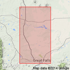
Named as the basal member of Blackleaf Formation of Colorado group (rank raised) for exposures along bluffs on west side of Missouri River near Flood Siding on the Great Northern Railway in NW1/4 sec 34, T20N, R3E, Cascade Co, MT on the Sweetgrass arch. Type section is on south side of Sun River valley 4.5 mi west of Great Falls in SW1/4 NW1/4 and NE1/4 sec 7, T20N, R3E. Consists of a lower part of light-brown ledge-making sandstone, a middle part of dark gray shale with interbeds of flaggy sandstone, and concretions of dark brown ironstone or iron-stained limestone, and an upper part of light-brown, massive, cliff-making sandstone that contains very large dark-weathering concretions of calcareous sandstone. Is 138 ft thick. Overlies Kootenai formation unconformably. Underlies Taft Hill glauconitic member (new) of Blackleaf on Sweetgrass arch, or Vaughn bentonitic member (new) of Blackleaf at East Glacier-Marias Pass. Is of Early Cretaceous, Albian age. Correlates with upper part of Cheyenne sandstone and with Fall River sandstone. Correlation chart.
Source: GNU records (USGS DDS-6; Denver GNULEX).
- Usage in publication:
-
- Flood Member*
- Modifications:
-
- Overview
- Revised
- Reference
- Dominant lithology:
-
- Sandstone
- Siltstone
- Claystone
- Shale
- AAPG geologic province:
-
- Sweetgrass arch
Summary:
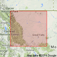
Is the lowest member of Blackleaf Formation of Colorado Group on Sweetgrass arch, MT. Term shale removed from name. Is a transgressive-regressive marine unit that lies between the Kootenai Formation and the Taft Hill Member of the Blackleaf. Measurement and description of type section. Reference section designated. Is 42+ m thick at type and 36.8 m thick at reference. Overlies Kootenai and underlies Blackleaf disconformably at type. Divided into three units at reference section: lower unit consists of yellow-brown, -gray or olive-gray, very fine to fine-grained sandstone, olive-gray, very fine grained siltstone, and dark gray, silty bentonitic claystone; middle unit composed of gray sandy siltstone, gray sandstone that may be fine to coarse grained, poorly sorted, subangular, friable noncalcareous, and gray to black shale; upper unit is mostly gray sandstone that ranges from fine to coarse grained, calcareous, and may be poorly sorted, cherty, and tuffaceous. Crops out in southern part of South arch and in Disturbed belt. Ranges from 26 to 60 m thick. Thickens west toward source area. Upper part dated (ammonites) as late Albian. Lower part not dated. Of Early Cretaceous age.
Source: GNU records (USGS DDS-6; Denver GNULEX).
- Usage in publication:
-
- Flood Member*
- Modifications:
-
- Areal extent
- AAPG geologic province:
-
- Montana folded belt
Summary:
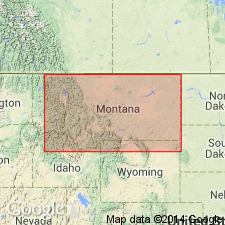
Flood Member of Blackleaf Formation can be recognized in the Snowcrest Range, Lima Peaks, and Pioneer Mountains of Beaverhead Co, MT in the Montana folded belt province, where it unconformably overlies the Kootenai Formation and underlies the Vaughn Member of the Blackleaf. These ranges are the east limit of the use of the name Flood. Is equivalent to the Thermopolis Shale and Muddy Sandstone, names that are used in the Gravelly and Greenhorn Ranges to the east. The axis of Ruby River valley which separates Snowcrest Range from the Greenhorn and Gravelly Ranges is the arbitrary location of the nomenclature change. Of Albian, Early Cretaceous age. Stratigraphic chart.
Source: GNU records (USGS DDS-6; Denver GNULEX).
- Usage in publication:
-
- Flood Member*
- Modifications:
-
- Overview
- AAPG geologic province:
-
- Montana folded belt
Summary:
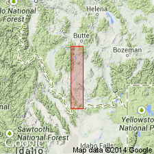
Is the lower member of Blackleaf Formation in the eastern Pioneer Mountains and Lima Peak areas, Beaverhead Co, MT, Montana folded belt province. Overlies gastropod limestone of Kootenai Formation. Underlies Vaughan Member of Blackleaf. Divided into lower clastic unit (= sandstone member of Thermopolis Shale), middle shale unit (= shale member of Thermopolis), and upper clastic unit (= Muddy Sandstone). Is equivalent to lower part of Colorado Group of Zen (1988). Few fossils found. Correlation chart. Of late Albian age. Measured sections.
Source: GNU records (USGS DDS-6; Denver GNULEX).
For more information, please contact Nancy Stamm, Geologic Names Committee Secretary.
Asterisk (*) indicates published by U.S. Geological Survey authors.
"No current usage" (†) implies that a name has been abandoned or has fallen into disuse. Former usage and, if known, replacement name given in parentheses ( ).
Slash (/) indicates name conflicts with nomenclatural guidelines (CSN, 1933; ACSN, 1961, 1970; NACSN, 1983, 2005, 2021). May be explained within brackets ([ ]).